
Parishes 14 Population 13,187 (2011) Local time Monday 11:01 AM | Subregion Alto Trás-os-Montes Elevation 797 m (2,615 ft) Postal code 5450 | |
 | ||
Weather 12°C, Wind NE at 3 km/h, 62% Humidity | ||
Vila pouca dos pequeninos vila pouca of little ones vila pouca de aguiar portugal
Vila Pouca de Aguiar ([ˈvilɐ ˈpowkɐ ðɨ ɐɣiˈaɾ]) is a municipality in the district of Vila Real in northern Portugal. The population in 2011 was 13,187, in an area of 437.07 km². The town proper has about 3,456 residents.
Contents
- Vila pouca dos pequeninos vila pouca of little ones vila pouca de aguiar portugal
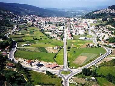
- Map of Vila Pouca de Aguiar Portugal
- Gala desporto vila pouca de aguiar 2010 i
- History
- Geography
- Twin towns Sister cities
- Economy
- Prehistoric
- Military
- Notable citizens
- References
Map of Vila Pouca de Aguiar, Portugal
Gala desporto vila pouca de aguiar 2010 i
History
The origin of Vila Pouca da Aguiar has caused differing opinions. Some authors hypothesis that "Vila Pouca" was the successor to the ancient city of "Cauca", which was governed by Emperor Theodosius I. Yet, this theory can not explain the name transition from Cauca to Pouca. Another belief is that "Vila Pouca" was a reference to a small agrarian community, and that "Aguiar" was a reference to an ancient administrative region. The name was, therefore, most likely, a phrase to disambiguate all the other communities named "Vila Pouca". Literally, the name means "Vila Pouca OF Aguiar", wherein etymologically, "aguiar" derived from the word aquila to designate "where the eagles are" (águia is Portuguese: eagle).
In the 13th century, the municipality of Vila Pouca de Aguiar was part of the land of Aguiar, much like other such as sites, like the Ribeira de Pena (or Portuguese: Ravine of Pena). In the 12 and 13th century, Aguiar was constituted by seven grande ecclesiastical parishes, which included São Salvador de Jugal, which corresponded to the actual parish of Vila Pouca de Aguiar. The Inquirições (inquiries/inventory) of King Afonso II established that the parochia of São Salvador de Jugal was composed of the localities and towns: Condado (three couples); Calvos (one couple); Guilhado (four couples) and Nuzedo (20 couples), in addition to the towns of Fraengo and Outeiro. The document also identifies Jugal as an administrative unit, with elaborated administrative domain over the territory of Aguiar, and where the parochial church was located, but no reference to Jugal as a town.
There is no indication as to the motives for changing the name from São Salvador de Jugal to Vila Pouca, nor the date, although it likely occurred sometime in the 14th century.
In the early 20th century, the leading figure in the area was Martiniano José Ferreira Botelho, a doctor, druggist and politician, known from his humanitarian character and support of the use of the local medicinal waters for treatments The Botelhos donated land to the community for the current market square, as well as the municipal slaughter house and well.
Geography
Integrated into the Alto Tâmega subregion, the municipality of Vila Pouca de Aguiar is situated in the north of the district of Vila Real, between the mountains of Serra do Alvão and Serra da Padrela, extending over a territory of approximately 437 km². It is located within a strategic connection, not just between other Portuguese municipalities in the interior but also, as a transit point to the coastal areas (across the A7 and A24 motorways). Within a long fertile valley, and surrounded by high pasture-lands, it is defensively safe within the Transmontana escarpments. The region is covered in national monuments and historical structures: the Castle of Aguiar da Pena, the millenarian Roman mining complex of Tresminas, the thermals of Pedras Salgadas, several leisure centres (such as the Falperra Dam/Reservoir), the Dolmens of Alvão, churches, graves/funeral sites, medieval bridges, sun-dials and castro dot the landscape of this unassuming region. It is located in a narrow valley 25 kilometers north of the district capital, Vila Real, and is connected to the same by national N2 highway.
In 2006 the A7 toll road to Guimarães was completed and the last stretch of the A24, connecting Vila Pouca with Vila Real was opened in June 2007. This non-toll four-lane highway links Coimbra with the Spanish border in Vila Verde. One of the longest and highest highway bridges in Europe was built just south of Vila Pouca, carrying traffic across the fertile valley.
Administratively, the municipality is divided into 14 civil parishes (freguesias):
Vila Pouca de Aguiar has for many years experienced the desertification of the Portuguese interior. Population densities have historically identified a strong concentration of people in the municipal seat, or its peripheral parishes. From 1981 to 1991, the parishes of Bragado, Pensalves, Afonsim, Vreia de Jales, Vreia de Bornes, Valoura and Soutelo de Aguiar have registered flawing population growth rates. The parish of Sabroso de Aguiar did not exist in 1981, but by 1991 it registered the highest population concentration in the region. Comparatively, between 1991 and 2001, there were no changes in population densities in many of the parishes. The municipal seat and Sabroso de Aguiar continue to show a growth in population density.
Twin towns — Sister cities
Vila Pouca de Aguiar is twinned with:
Economy
Part of region characterized by fertile soils, and the typical climate of the Terra Fria Transmontana, the municipality of Vila Pouca de Aguiar is essentially subsistence agricultural, cultivating cereal crops, potato, vegetables and supporting some vineyards. The small valleys support cattle which graze in the open pasturelands. The lands of the Alvão valley benefited from the construction of the Alvão Dam/Reservoir, which allowed irrigation of these lands since the mid-20th century.
In addition, the economy supports small service industries, government-based dominated teritary employment, the granite extraction industry (concentrated in the mines of Jales) and the mineral waters in Pedras Salgadas, a small spa town located about ten kilometers north on the main highway to Chaves.