
Location Northern Canada Highest elevation 655 m (2,149 ft) Area 217,291 km² Population 1,875 (2006) Ethnic groups Inuit | Area rank 8th Highest point Unnamed Elevation 655 m Length 700 km (430 mi) | |
 | ||
Archipelago Canadian Arctic Archipelago Width 564–623 km (350–387 mi) Coordinates 71°N 110°W / 71°N 110°W Coordinates: 71°N 110°W / 71°N 110°W Largest settlement Cambridge Bay, Nunavut (pop. 1,477) | ||
Victoria Island (or Kitlineq) is a large island in the Canadian Arctic Archipelago that straddles the boundary between Nunavut and the Northwest Territories of Canada. It is the eighth largest island in the world, and at 217,291 km2 (83,897 sq mi)1 in area, it is Canada's second largest island. It is nearly double the size of Newfoundland (111,390 km2 (43,008 sq mi)), and is slightly larger than the island of Great Britain (209,331 km2 (80,823 sq mi)). It contains the world's largest island within an island within an island. The western third of the island belongs to the Inuvik Region in the Northwest Territories; the remainder is part of Nunavut's Kitikmeot Region.
Contents
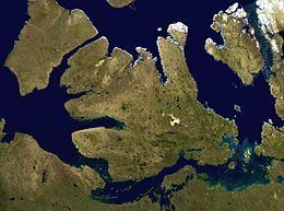
Map of Victoria Island, Canada
History
In 1826 John Richardson saw the southwest coast and called it "Wollaston Land". In 1839 Peter Warren Dease and Thomas Simpson followed its southeast coast and called it "Victoria Land". A map published by John Barrow in 1846 shows a complete blank from these two lands north to "Banks Land" which is the north coast of Banks Island. In 1851 John Rae charted its entire south coast and connected the two "lands". In 1850 and 1851 Robert McClure circumnavigated most of Banks Island, thereby separating it from the rest of Victoria Land. His men also charted the northwest and west coasts of Victoria Island. One of Roald Amundsen's men, Godfred Hansen, charted its east coast as far as Cape Nansen in 1905, and in 1916 and 1917 Storker T. Storkerson, of Vilhjalmur Stefansson's Canadian Arctic Expedition, charted its northeast coast, discovering the Storkerson Peninsula.
Location and description
Viscount Melville Soundmap1 lies to the north, and the M'Clintock Channelmap2 and Victoria Straitmap3 lie eastward. On the west are Amundsen Gulfmap4 and Banks Island,map5 which is separated from Victoria by a long sound called the Prince of Wales Strait.map6 To the south (from west to east) lies the Dolphin and Union Strait,map7 Austin Bay,map8 Coronation Gulfmap9 and the Dease Strait.map10
The southern waterways, and sometimes the Prince of Wales Strait, form part of the disputed Northwest Passage which the Government of Canada claims are Canadian Internal Waters, while other nations state they are either territorial waters or international waters.
Victoria Island is an island of peninsulas, having a heavily indented coastline with many inlets. In the east, pointing northwards, is the Storkerson Peninsula,map11 which ends with the Goldsmith Channel,map12 the body of water separating Victoria from Stefansson Island.map13 The Storkerson Peninsula is separated from the island's north-central areas by Hadley Bay,map14 a major inlet. Another, broad peninsula is found in the north, Prince Albert Peninsula.map15 This ends at the Prince of Wales Strait. In the south, and pointing westwards, is the Wollaston Peninsula,map16 separated from the island's central areas by Prince Albert Sound. The island as a whole coincidentally resembles a stylized maple leaf, the main Canadian symbol.
The highest point of Victoria Island is 655 m (2,149 ft) in the Shaler Mountainsmap17 in the north-central region. Located in the southeast, just north of Cambridge Bay is Ferguson Lakemap18 with an area of 562 km2 (217 sq mi) is the largest lake on the island.
The island is named after Queen Victoria, the Canadian sovereign from 1867 to 1901. The features bearing the name "Prince Albert" are named after her consort.
There is also a smaller Victoria Island in Nunavut, located in Amadjuak Lake on Baffin Island.
The Dolphin-Union Caribou herd locally known as Island Caribou, are a migratory population of barren-ground caribou, Rangifer tarandus groenlandicus, that occupy Victoria Island in Canada's High Arctic and the nearby mainland. They are endemic to Canada. They migrate across the Dolphin and Union Strait from their summer grazing on Victoria Island to their winter grazing area on the Nunavut-NWT mainland in Canada. It is unusual for North American caribou to seasonally cross sea ice and the only other caribou to do so are the Peary caribou who are smaller in size and population.
Demographics
In the Canada 2006 Census the population of the island was 1,875; 1,477 in Nunavut and 398 in the Northwest Territories. Of the two settlements on the island the largest is Cambridge Bay,map19 which lies on the south-east coast and is in Nunavut. Ulukhaktokmap20 is on the west coast and is in the Northwest Territories. Trading posts, such as Fort Collinsonmap21 on the northwest coast, have long since been abandoned.