
Time zone CET (UTC+1) Website www.vianen.nl Local time Sunday 9:16 PM | Elevation 4 m (13 ft) Postcode 4130–4133 Area 42.37 km² Area code 0347 | |
 | ||
Weather 11°C, Wind NW at 11 km/h, 76% Humidity | ||
Vianen ( [viˈjaːnə(n)]) is a municipality and a city in the central Netherlands, in the province of Utrecht. It is the only municipality in Utrecht located south of the Lek River. Before 2002 it was part of the province of South Holland. Vianen is bordered by two major motorways leading to Utrecht: the A2 (Amsterdam-Maastricht) on its west, and the A27 (Breda-Almere) just east of the town. Both roads can be notoriously congested near Vianen during peak commute hours.
Contents
Map of Vianen, Netherlands
Population centres
(Population as of February, 2006)
Dutch topographic map of the municipality of Vianen, June 2015
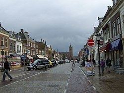
The city of Vianen
Vianen received city rights in 1337. Vianen thrived under the counts of Brederode, who acquired its lordship through marriage early in the 15th century. It formed a self-proclaimed sovereign seignory till 1795, including Vianen, Lexmond, Hei- en Boeicop and Meerkerk. During the Middle Ages, as a "free city," Vianen could be a haven for felons and escaped serfs. Of the three castles built during the town's history, Castle Batestein was said to be one of the most beautiful in the Netherlands. Its only remnants are a 17th-century brick gate and water-pump. Remnants of the old city wall are visible girdling parts of the old downtown.
Vianen celebrates its city rights every year in October with a horse-market. Besides the horses there are also other activities on this day, such as a fair and market and traditional Dutch games.