
Country United States County Jennings Time zone Eastern (EST) (UTC-5) Elevation 202 m Zip code 47282 Population 317 (2013) | State Indiana FIPS code 18-78902 Area 62 ha Local time Sunday 7:16 AM Area code 812 | |
 | ||
Weather 3°C, Wind E at 8 km/h, 95% Humidity | ||
Watching the valley mt vernon indiana industrial tour
Vernon is a town in Vernon Township, Jennings County, Indiana, United States. It is the county seat of Jennings County. With a population of 318 in the 2010 census, it is the smallest town with that designation in the state of Indiana. It is nearly surrounded by the Muscatatuck River. Vernon has the only elected mayor of a town in the state of Indiana and the only elected town marshal. As of 2010, Dan Wright is Mayor and Britt Burgmeier is the Marshal.
Contents
- Watching the valley mt vernon indiana industrial tour
- Map of Vernon IN USA
- Walkaround of city of madison port authority railroad north vernon indiana 15 08 11
- History
- Geography
- 2010 census
- 2000 census
- Notable people
- Literature
- References
Map of Vernon, IN, USA
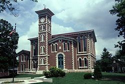
The Vernon Historic District is on the National Register of Historic Places and is the host of many firsts in the state.
It was also the home of Indiana's fourth state park, now called Muscatatuck County Park.
Walkaround of city of madison port authority railroad north vernon indiana 15 08 11
History
Vernon was named after Mount Vernon. The Vernon post office was established in 1817.
Geography
According to the 2010 census, Vernon has a total area of 0.24 square miles (0.62 km2), all land.
2010 census
As of the census of 2010, there were 318 people, 134 households, and 84 families residing in the town. The population density was 1,325.0 inhabitants per square mile (511.6/km2). There were 167 housing units at an average density of 695.8 per square mile (268.6/km2). The racial makeup of the town was 97.5% White, 0.3% African American, 0.3% Asian, 0.3% from other races, and 1.6% from two or more races. Hispanic or Latino of any race were 0.6% of the population.
There were 134 households of which 35.1% had children under the age of 18 living with them, 46.3% were married couples living together, 12.7% had a female householder with no husband present, 3.7% had a male householder with no wife present, and 37.3% were non-families. 32.8% of all households were made up of individuals and 11.1% had someone living alone who was 65 years of age or older. The average household size was 2.37 and the average family size was 2.92.
The median age in the town was 39.3 years. 26.4% of residents were under the age of 18; 7.2% were between the ages of 18 and 24; 25.5% were from 25 to 44; 27% were from 45 to 64; and 13.8% were 65 years of age or older. The gender makeup of the town was 48.1% male and 51.9% female.
2000 census
As of the census of 2000, there were 330 people, 117 households, and 80 families residing in the town. The population density was 1,383.2 people per square mile (530.9/km²). There were 139 housing units at an average density of 582.6 per square mile (223.6/km²). The racial makeup of the town was 98.48% White, 0.91% African American, 0.30% Native American and 0.30% Asian.
There were 117 households out of which 32.5% had children under the age of 18 living with them, 49.6% were married couples living together, 15.4% had a female householder with no husband present, and 31.6% were non-families. 27.4% of all households were made up of individuals and 14.5% had someone living alone who was 65 years of age or older. The average household size was 2.40 and the average family size was 2.83.
In the town, the population was spread out with 20.9% under the age of 18, 11.5% from 18 to 24, 33.6% from 25 to 44, 19.7% from 45 to 64, and 14.2% who were 65 years of age or older. The median age was 35 years. For every 100 females there were 124.5 males. For every 100 females age 18 and over, there were 123.1 males.
The median income for a household in the town was $29,750, and the median income for a family was $36,875. Males had a median income of $28,333 versus $22,143 for females. The per capita income for the town was $17,367. About 5.2% of families and 9.5% of the population were below the poverty line, including 18.1% of those under age 18 and 4.3% of those age 65 or over.
Notable people
General Robert S. Foster, officer in the Civil War; Lincoln Dixon, a member of the U.S. Congress; Sarah T. Bolton, pioneer poet; Shirley Dare, magazine writer; John C. New, U.S. Consul General to Great Britain and publisher of the Indianapolis Journal; Ovid Butler, founder of Butler University; Horatio C Newcomb, Mayor of Indianapolis; Phyliss Jackson, author; William Forsyth and Theodore Steele, artists.
Famous people who visited and lived in Vernon include: Alexander Campbell, founder of the Christian Church and Bethany College; Henry Ward Beecher came to Vernon early in the Civil War and made a plea for Lincoln and the Union at the Courthouse; and Lord Flanigan, English nobleman, was at one time a citizen of Vernon. Richard Nixon spoke in front of the courthouse in Vernon on June 24, 1971 for the dedication of a plaque commemorating the birthplace of his mother, Hannah Milhous Nixon.
Literature
In Jessamyn West's book, "The Friendly Persuasion", the Birdwell family lives near Vernon.