
Peak Grand Veymont Width 40 km (25 mi) West Elevation 2,341 m Highest point Grand Veymont Parent range Alps | Length 60 km (37 mi) North Region Rhône-Alpes Area 1,350 km² Country France | |
 | ||
Mountains Mont Aiguille, Grand Veymont, Moucherotte, Col de Rousset Similar Chartreuse Mountains, Alps, Mont Aiguille, Grand Veymont, Belledonne | ||
The Vercors Massif is a range in France consisting of rugged plateaux and mountains straddling the départements of Isère and Drôme in the French Prealps. It lies west of the Dauphiné Alps, from which it is separated by the rivers Drac and Isère. The cliffs at the massif's eastern limit face the city of Grenoble.
Contents
- Map of Vercors Massif 38250 CorrenC3A7on en Vercors France
- 360 video explore the choranche cave in the vercors massif
- BackgroundEdit
- EtymologyEdit
- LocationEdit
- GeomorphologyEdit
- Sub divisionsEdit
- Principal summitsEdit
- Principal road colsEdit
- GeologyEdit
- Vercors in popular cultureEdit
- References
Map of Vercors Massif, 38250 Corren%C3%A7on-en-Vercors, France
360 video explore the choranche cave in the vercors massif
BackgroundEdit
Over time, various features of the complex geography have been recognised including, the Quatre Montagnes (four mountains), the Coulmes (gorges), the Vercors Drômois (Drome Vercors), the Hauts-Plateaux (high plateau) and, in the foothills, Royans, Gervanne, Diois, and Trièves.
The massif is sometimes called the fortress. The movement of people tends to be between the massif and the surrounding plains rather than between the various parts of the massif itself.
Until the mid twentieth century, the name, Vercors was used to describe only the township of La Chapelle-en-Vercors (with Royans), and the northern area around Lans-en-Vercors, Villard-de-Lans, Autrans, and Méaudre (with Grenoble) and was known as the Four Mountains area.
In June and July 1944, the massif became important in World War II with the establishment of the Free Republic of Vercors, led by the Maquis du Vercors, a base for the French Resistance against German occupation.
In the massif's karstic area is the Vercors Cave System and the Gouffre Berger.
The Vercors has several resorts for cross-country skiing and for down-hill skiing. Villard-de-Lans is the biggest down-hill ski resort.
This sporting area is environmentally protected, and although the natural environment has been drastically altered throughout history for the purposes of agriculture and forestry, plans for afforestation will make it one of the major forests of Metropolitan France and a reserve for species such as the southern tulip and black grouse, two symbols of the park, as well as the re-introduced griffon vulture and the alpine ibex. The differences in climate and altitude across the Vercors are reflected in the high level of diversity in the fauna and flora.
EtymologyEdit
The name Massif du Vercors is derived from the name of a local tribe who lived in the area at the time of the Roman conquest of Gaul, who were known as the Vertamocorii (also spelled Vertamocori, Vertacomicorii, or Vertacomocorii), meaning excellent troops or troops of the summit. Modern inhabitants are referred to as Vertacomiriens.
Prior to the 1900s, the name Vercors referred to the upper valleys of the Vernaison near the township of La Chapelle-en-Vercors. At the beginning of the 20th century, Henri Ferrand explored the massif, taking numerous photographs, publishing books, and describing the geology of the mountains. Ferrand was the first to use the term Vercors in its contemporary sense. The geographers Raoul Blanchard and Jules Blache, popularised the term in the late 1920s and early 1930s. By the 1950s, the term was ubiquitous.
LocationEdit
The Vercors Massif lies in the Prealps, in the south-east France, straddling the departments of Drôme and Isère, both of which are part of the Rhône-Alpes region, about 100 kilometres (62 mi) south-east of Lyon. The massif covers 135,000 hectares (520 sq mi) with a north-south length of 60 kilometres (37 mi) and an east-west width of 40 kilometres (25 mi).
The massif is surrounded by the Chartreuse Mountains to the north, the Matheysine area of the Dauphiné Alps to the east, and the Diois Massif to the south. In the far south-east, the massif joins with the 1,457 metres (4,780 ft) col de Menée.
The massif is drained in the north-east and the north-west by the Isère river, in the east by the Drac, and in the south by the Drôme. The western side overlooks the Rhône Valley.
GeomorphologyEdit
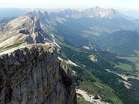
The Vercors Massif is known as the fortress or as the French dolomites because of its geomorphology. The massif is likened to a plateau: the fall from the massif to its inner valleys is a few hundred metres, while the fall to the surrounding areas is between 800 metres (2,600 ft) and 1,200 metres (3,900 ft).
The crest of the eastern edge has several summits over 2,000 metres (6,600 ft). The interior varies between 800 metres (2,600 ft) and 1,500 metres (4,900 ft). The massif also has wide valleys including the valley of Lans-en-Vercors, the regions around Autrans, and La Chapelle-en-Vercors, and plateaus including forêt des Coulmes, forêt de Lente, and the high plateau. There are deep chasms including the Bourne and Furon gorges. The chasms have imposing cliffs often exceeding 400 metres (1,300 ft) and include the Combe Laval and the Cirque d'Archiane.
Mont Aiguille stands apart from the rest of the massif as the result of erosion. Other parts are isolated from the rest of the massif due to its relief. For example, to reach Gresse-en-Vercors in the south, one must travel 100 kilometres (62 mi) via the col de Rousset or journey 70 kilometres (43 mi) via Saint-Nizier-du-Moucherotte in the north. The villages at the far northern end were isolated by a landslide near the Mortier tunnel. Another example is the Peuil plateau in the east. During the Ice Age, the Grésivaudan glacier reached the Peuil plateau leaving a marsh.
Sub-divisionsEdit
The central part of the Vercors Massif is divided into several regions.
The coulmes, in the north-west, are heavily covered in forest. Folds of urgonian limestone are rounded, making the area appear mountainous.
The four mountains area has been developed for tourism and skiing but is also known for its traditional activities such as the breeding of dairy cows and cheese making. The main villages, Autrans, Méaudre, Lans-en-Vercors, and Villard-de-Lans, are spread over two plateaux covered by wooded hills.
The Drômois Vercors is an area made up of a number of smaller plateaux. In the north of the Drômois Vercors there are several gorges which are traversed by roads cut into the cliffs. Grassy areas are used as pastures in the summer months, and the biannual migration (transhumance) of animals is a period of celebration for the people of Die.
The Haut-Plateaux (high plateaux) are the highest wilderness areas of the massif. The area is managed and the pastures are used for grazing in the summer.
At the fringes of the massif, the Vercors regional park has four geographical areas. The Royans, the north-west foothills are the location of walnuts growing. Three valleys descend to the edge of the Royans: the Gorges de la Bourne, the cirque of the Combe Laval, and the Échevis valley, including the Grands and the Petits Goulets.
The Gervanne, in the south-west, is a rugged area of hills at the foot of the plateau, with picturesque villages. It looks towards Crest.
The Diois is a part of the Drôme valley around Die. This region has a Mediterranean character, with vineyards and fields of lavender. It acts as a buffer between Gervanne and the interior of the massif.
The Trièves, in the east, is a low hilly plateau, which lies between the highest summits of the Vercors and the gorge carved out by the Drac river.
Principal summitsEdit
From north to south:
Principal road colsEdit
By descending altitude:
The Tunnel du Mortier links Montaud with Autrans, at an altitude of 1,391 metres (4,564 ft). It was closed on 20 April 1992 after a landslide of 20,000 m3 of rock which involved part of the slope to the north of the route. The instability of the slopes have proved an impediment for the realisation of further work below the site, particularly work on the gorges d'Engins to Sassenage road, the D531.
GeologyEdit
The constituent rocks of the Vercors were formed by sedimentation about 165 million years ago, in the middle Jurassic period, at the bottom of the Piemont-Liguria Ocean. The deposition of animal material formed limestone, with detritus rocks, formed primarily from the erosion of marl from the Variscan orogeny formed the massif in a period marked by changing climactic conditions and ocean depth. At Diois and Trièves is a layer of the massif, formed in the Tithonian era. Then, about 130 million years ago, in the Cretaceous era, a rise in temperatures combined with shallow waters led to the development of coral reefs, which abounded with molluscs, particularly rudists. These were the origin of the urgonian limestone which forms the upper part of the massif, more prominently in the northern half. This primitive fauna left numerous fossils, some of which have been found at a site near Rencurel in the coulmes.
In the Paleogene era, the Tethys ocean closed up and at the start of the Miocene, the raising of the alps resulted in a nappe (thrust shift) to the west and rocks of sedimentary origin were raised 2,000 metres (6,600 ft) above the current location of the Massif des Écrins. The folding of these rocks resulted in the Vercors having local synclines and anticlines successively and, due to the hardness of the rock, there are faults.
Subsequent marine transgressions were responsible for secondary sedimentation in the basins. There was widening of the gorges and erosion of the cliffs from runoff, leading to the formation of the Molasses in the Royans and also in the valleys of Lans, Autrans, and Rencurel. At the close of the Miocene, a new period of uplifting brought about the final receding of the sea.
Once formed, the massif underwent severe erosion, which accentuated the relief. The different synclines grew larger, eventually forming valleys including those of Autrans, Méaudre and Lans, Villard, Corrençon, the Col de Romeyère and the Col de Rousset. The water hollowed out the cirque of Archiane, the Steephead valley of Bournillon, and the combe Laval.
Vercors in popular cultureEdit
The Vercors have appeared in many films, including;