
Suburban Development Area Core Neighbourhoods Annexed 1911 Area 127 ha Local time Saturday 7:39 AM | Neighbourhood Varsity View Construction 1912-1960 Population 3,611 (2007) | |
 | ||
Weather 3°C, Wind S at 23 km/h, 81% Humidity | ||
Home for sale varsity view saskatoon sk interior video
Varsity View is a mostly residential neighbourhood located near central Saskatoon, Saskatchewan, Canada. It is immediately south of the University of Saskatchewan campus. It is an older suburban subdivision, comprising a mixture of low-density, single detached dwellings, detached duplexes and apartment-style units. As of 2007, the area is home to 3,611 residents. The neighbourhood is considered a middle-income area, with an average family income of $50,587, an average dwelling value of $284,710 and a home ownership rate of 38.7%. Its proximity to the university gives this area its relatively high student population, almost 25% in 2005. According to MLS data, the average sale price of a home as of 2013 was $402,332.
Contents
- Home for sale varsity view saskatoon sk interior video
- Map of Varsity View Saskatoon SK Canada
- History
- Government and politics
- Education
- Other
- Parks and recreation
- Commercial
- Location
- References
Map of Varsity View, Saskatoon, SK, Canada
History
Development was spurred by the establishment of the University of Saskatchewan in 1907. The land for the Varsity View neighbourhood was annexed by the city in 1911; it was among the first parcels of land annexed after Saskatoon's incorporation five years earlier. The first homeowner was Richard Bottomley, an English real estate developer who was said to have invested $1.5 million in the real estate boom of 1912. His house, now referred to as Bottomley House, is a large, Queen Anne Revival style home. It was designated a municipal heritage property on April 24, 2006.
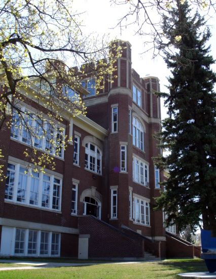
In 1911, the school board purchased the block in which the Albert School would be constructed; it opened in 1912 at 610 Clarence Avenue South. It was designed in the Collegiate Gothic style by Scottish architect David Webster, who also designed several similar-looking schools (King George, King Edward, Buena Vista, Westmount, Caswell and Alexandra). Besides serving as an educational centre, Albert School played a big role in city sports, especially lacrosse and hockey. It was also used for other purposes, such as English classes for large numbers of Ukrainians in 1916.
According to a 1913 map, the current neighbourhood encompasses a collection of registered subdivisions were originally named University Annex, Bottomley Addition, Varsity Park and College Park (which would be reused to designate another neighbourhood). College Drive and Elliott Street were not substantially developed until the late 1920s, while neighbouring Osler Street had to wait for residential construction until the early 1950s. The majority of the housing stock was built between 1946 and 1960. The oldest homes are located at the neighbourhood's north and west ends, as development progressed from the university campus and Nutana's eastern edge. Two more schools, Brunskill and Bishop Murray, opened in the 1950s.
After more than seventy years, a drop in enrollments brought the closing of Albert School in 1978, after which it served as the centre for l'Ecole Francaise de Saskatoon. It became the Albert Community Centre in 1982, sparing it from the wrecking ball. It was officially designated a municipal heritage property on October 11, 1983.
Government and politics
Varsity View exists within the federal electoral district of Saskatoon-Humboldt. It is currently represented by Brad Trost of the Conservative Party of Canada, first elected in 2004 and re-elected in 2006.
Provincially, Varsity View overlaps three separate constituencies:
In Saskatoon's non-partisan municipal politics, Varsity View lies within ward 6. It is currently represented by Councillor Charlie Clark, first elected in 2006.
Education
Other
Parks and recreation
The planting of 1500 spruce trees in President Murray Park was done under the supervision of Wyndham Winkler Ashley, a charter member of the Saskatoon Parks Board in 1912. W.W. Ashley Park in the Haultain neighbourhood was named in his honour.
The Varsity View Community Association organizes events, delivers recreational and leisure programs, coordinates sports programs for children/youth and maintains the outdoor rink at Brunskill School.
Commercial
Commercial development is limited; some businesses are located at the southern edge of the neighbourhood, within the 8th Street business district. There are also a few businesses clustered near College Drive and Cumberland Avenue, bordering the University of Saskatchewan campus. A couple of businesses also exist adjacent to Brunskill School on Temperance Street and Wiggans Avenue. 43 home-based businesses exist in the neighbourhood. Closest major commercial developments are the Central Business District (aka Downtown), and the 8th Street and Broadway Avenue business strips.
Location
Varsity View is located within the Core Neighbourhoods Suburban Development Area. It is bounded by College Drive to the north, 8th Street to the south, Cumberland Avenue to the east, and Clarence Avenue to the west. Roads are laid out in a grid fashion; streets run east-west, avenues run north-south. The University Bridge connects the north end of the neighbourhood to the west side of Saskatoon.