
Reference no. 150 Phone +1 702-397-2088 | Area 185.9 km² Designated as world heritage site 1968 | |
 | ||
Hours Open today · 6:30AM–7PMFriday6:30AM–7PMSaturday6:30AM–7PMSunday6:30AM–7PMMonday6:30AM–7PMTuesday6:30AM–7PMWednesday6:30AM–7PMThursday6:30AM–7PMSuggest an edit Similar Red Rock Canyon National, Lake Mead, Hoover Dam, Zion National Park, Death Valley National Profiles | ||
7 hikes in valley of fire state park nevada
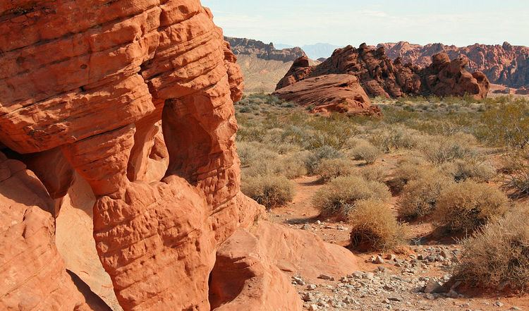
Valley of Fire State Park is a public recreation and nature preservation area covering nearly 46,000 acres (19,000 ha) located 16 miles (26 km) south of Overton, Nevada. The state park derives its name from red sandstone formations, the Aztec Sandstone, which formed from shifting sand dunes 150 million years ago. These features, which are the centerpiece of the park's attractions, often appear to be on fire when reflecting the sun's rays. It is Nevada's oldest state park, as commemorated with Nevada Historical Marker #150. It was designated as a National Natural Landmark in 1968.
Contents
- 7 hikes in valley of fire state park nevada
- Valley of fire state park nevada
- GeologyEdit
- HistoryEdit
- ClimateEdit
- Valley of Fire RoadEdit
- Park featuresEdit
- Film historyEdit
- References
Valley of Fire is located 50 miles (80 km) northeast of Las Vegas, at an elevation between 1,320–3,009 feet (402–917 m). It abuts the Lake Mead National Recreation Area on the east at the Virgin River confluence. It lies in a 4 by 6 mi (6.4 by 9.7 km) basin.
Valley of fire state park nevada
GeologyEdit
Complex uplifting and faulting of the region, followed by extensive erosion, have created the present landscape. The rough floor and jagged walls of the park contain brilliant formations of eroded sandstone and sand dunes more than 150 million years old. Other important rock formations include limestones, shales, and conglomerates.
HistoryEdit
Prehistoric users of the Valley of Fire included the Ancient Pueblo Peoples, also known as the Anasazi, who were farmers from the nearby fertile Moapa Valley. Their approximate span of occupation has been dated from 300 BC to 1150 AD. Their visits probably involved hunting, food gathering, and religious ceremonies, although scarcity of water would have limited their stay. Fine examples of rock art (petroglyphs) left by these ancient peoples can be found at several sites within the park.
The creation of Valley of Fire State Park began with transfer of 8,760 acres (3,550 ha) of federal land to the state at Nevada in 1931. Work on the park was initiated by the Civilian Conservation Corps in 1933. The park opened in 1934; it achieved official designation by the state legislature in 1935.
ClimateEdit
The Valley of Fire State Park has a dry and warm climate typical of the Mojave Desert in which it lies. Winters are mild with daytime temperatures ranging from 54 °F (12 °C) to 75 °F (24 °C). and over night lows in the mid 30°F's to mid 40°F's (3-8°C). Storms moving east from the Pacific Ocean occasionally bring rain during winter months. Daily summer highs usually range from 100 °F (38 °C) to 115 °F (46 °C) and on occasion may reach near 120 °F (49 °C). Thunderstorms from the Southwestern Monsoon can produce heavy showers during summer. The average annual precipitation is 6.50" (165.1mm).
Valley of Fire RoadEdit
Valley of Fire Road is the main road through the park. The 10.5 mi (16.9 km) road connects the east and west entrances of the park. It was designated as a Nevada Scenic Byway on June 30, 1995.
Park featuresEdit
Although petroglyphs are present throughout the entire park, Mouse's Tank and Atlatl Rock are two areas in particular which have many petroglyphs while being relatively easily accessible. The park also contains three cabins built by the Civilian Conservation Corps. There are facilities for picnicking, camping, and hiking.
Film historyEdit
Valley of Fire is a popular location for shooting automobile commercials and other commercial photography. It has provided a setting for the following films and television shows: