
Long-axis length around 30 km (19 mi) Province Province of Turin | ||
 | ||
Floor elevation 600–3,060 m (1,970–10,040 ft) Similar Alps, Colle Sestriere, Susa Valley, Cottian Alps, Colle delle Finestre | ||
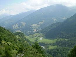
The Valle Germanasca is a valley in the province of Turin, Piedmont, north-western Italy run by the Germanasca stream, a right affluent of the Chisone.
Contents
Map of Valle della Germanasca, 10060 Prali, Metropolitan City of Turin, Italy
The valley is a renowned summer tourist resort, its main attraction being its natural landscape. The main resort is Ghigo, a frazione of the commune of Prali. Also visited are the Talc mines of the valley, which are of its main resources and are still active.
Valle Germanasca is one the Piedmontese valleys in which the majority of the population belongs to the Waldensian Evangelical Church.
Notable summits
Among the summits which surround the valley (all belonging to the Cottian Alps) there are:
References
Valle Germanasca Wikipedia(Text) CC BY-SA