
Country Canada Region Outaouais Time zone EST (UTC−5) Population 10,625 (2011) | Province Quebec Constituted January 1, 1975 Postal code(s) J8N 4E9 Local time Monday 8:01 PM | |
 | ||
RCM Les Collines-de-l'Outaouais Weather 3°C, Wind E at 16 km/h, 53% Humidity Points of interest Arbraska : Parc Laflèche, Plage Municipal St Pierre, Baie Courville | ||
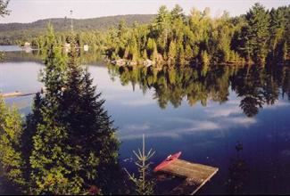
Val-des-Monts is a municipality in the Outaouais region of Quebec, Canada, located about 40 kilometres north of Ottawa. It has a population of 10,625 residents. Formed in 1974 by the merger of the towns of Perkins, Saint-Pierre-de-Wakefield and Poltimore, it consists mainly of farms and mountainous forests. Many of its residents commute to Ottawa or Gatineau for work. Due to its numerous lakes, recreational opportunities and cottages its population is boosted during weekends and holidays by visitors from nearby Ottawa and Gatineau.The largest of the town's many lakes is Lac McGregor followed by Lac Saint-Pierre and Lac Grand, which are all highly popular among cottagers. Most of the people in Val-des-Monts live in the village of Perkins.
Contents
Map of Val-des-Monts, QC, Canada
Earthquake
On June 23, 2010, at 1:41 p.m. ET, a magnitude 5.0 earthquake hit Val-des-Monts. The earthquake was felt as far as Montreal, Boston and Cleveland.