
Country Switzerland SFOS number 6512 Postal code 2112 | Elevation 737 m (2,418 ft) Local time Tuesday 2:00 AM | |
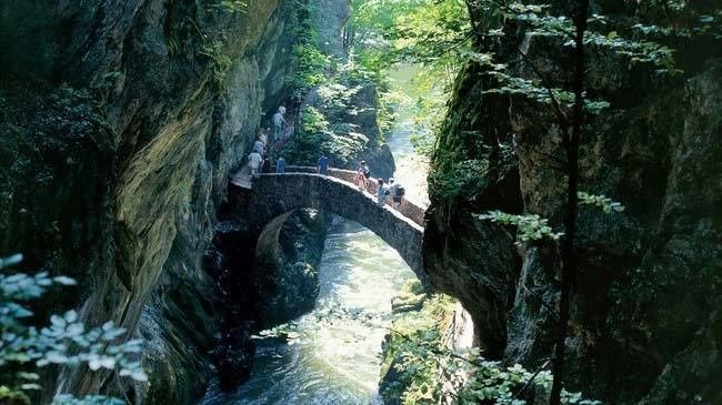 | ||
Website www.val-de-travers.ch SFSO statistics Weather 5°C, Wind NE at 5 km/h, 86% Humidity Points of interest Mauler & Cie SA, Poëta‑Raisse‑Schlucht, Musée d'épaves oldtimer, Musée régional du Val‑de‑Travers, Absintherie et Musée du Père F | ||
Visiter val de travers
Val-de-Travers is a municipality in the district of Val-de-Travers in the canton of Neuchâtel in Switzerland. It was created on 1 January 2009, when the former municipalities of Boveresse, Buttes, Couvet, Fleurier, Les Bayards, Môtiers, Noiraigue, Saint-Sulpice and Travers merged to form Val-de-Travers.
Contents
- Visiter val de travers
- Map of Val de Travers Switzerland
- Live val de travers
- History
- Geography
- Demographics
- Heritage sites of national significance
- Economy
- Education
- References
Map of Val-de-Travers, Switzerland
The region is known for its production of absinthe.
Live val de travers
History
Val-de-Travers is first mentioned in 1150 as Vallis traversis.
Geography
Val-de-Travers has an area, as of 2009, of 124.9 square kilometers (48.2 sq mi). Of this area, 52.92 km2 (20.43 sq mi) or 42.4% is used for agricultural purposes, while 63.24 km2 (24.42 sq mi) or 50.6% is forested. Of the rest of the land, 7.54 km2 (2.91 sq mi) or 6.0% is settled (buildings or roads), 0.59 km2 (0.23 sq mi) or 0.5% is either rivers or lakes and 0.39 km2 (0.15 sq mi) or 0.3% is unproductive land.
Of the built up area, housing and buildings made up 2.5% and transportation infrastructure made up 2.5%. Out of the forested land, 46.8% of the total land area is heavily forested and 3.8% is covered with orchards or small clusters of trees. Of the agricultural land, 5.0% is used for growing crops and 23.9% is pastures and 13.4% is used for alpine pastures. All the water in the municipality is flowing water.
The municipality is located in a valley in the Neuchâtel Jura. The valley provides a connection between the Swiss plateau and Franche-Comte.
The river L'Areuse (previous called La Reuse, the name morphed into Areuse), flows lengthways of the valley, most of this river is a shallow river, and about 10 meters wide, it narrows into a gorge near Noiraigue. historically, this river provided much of the water and fish for the valley.
Demographics
Val-de-Travers has a population (as of December 2015) of 10,905. As of 2008, 18.0% of the population are resident foreign nationals. Over the last 10 years (2000–2010) the population has changed at a rate of -2.5%. Migration accounted for -1.8%, while births and deaths accounted for -1.6%.
Most of the population (as of 2000) speaks French (88.9%) as their first language, Italian is the second most common (3.0%) and German is the third (2.7%).
As of 2008, the population was 48.6% male and 51.4% female. The population was made up of 4,161 Swiss men (38.4% of the population) and 1,103 (10.2%) non-Swiss men. There were 4,677 Swiss women (43.2%) and 891 (8.2%) non-Swiss women.
As of 2000, children and teenagers (0–19 years old) make up 25% of the population, while adults (20–64 years old) make up 55.9% and seniors (over 64 years old) make up 19.1%.
As of 2009, the construction rate of new housing units was 0.6 new units per 1000 residents. The vacancy rate for the municipality, in 2010, was 1.39%.
Heritage sites of national significance
The Farm House no. 1201 or Monlési, the Maison des Chats or Petitpierre, the Séchoir à absinthe, Ivernois Castle and the Maison Boy de la Tour, the Hôtel des Six-Communes, the medieval church of St-Pierre, the Temple in Môtiers and Areuse Bridge are listed as Swiss heritage site of national significance. The villages of Buttes, Les Verrières, Môtiers, Couvet, Fleurier and Travers are all part of the Inventory of Swiss Heritage Sites.
Economy
As of 2010, Val-de-Travers had an unemployment rate of 6.6%. As of 2008, there were 322 people employed in the primary economic sector and about 139 businesses involved in this sector. 1,980 people were employed in the secondary sector and there were 162 businesses in this sector. 2,188 people were employed in the tertiary sector, with 374 businesses in this sector. There were residents of the municipality who were employed in some capacity. Of the working population, 13.1% used public transportation to get to work, and 57.3% used a private car.
Education
In the canton of Neuchâtel most municipalities provide two years of non-mandatory kindergarten, followed by five years of mandatory primary education. The next four years of mandatory secondary education is provided at thirteen larger secondary schools, which many students travel out of their home municipality to attend. During the 2010-11 school year, there were 10.5 kindergarten classes with a total of 198 students in Val-de-Travers. In the same year, there were 29 primary classes with a total of 528 students.