
Established c. 1828 Time zone AEST (UTC+10) Postal code 2421 | Postcode(s) 2421 Area 59.5 km² Population 547 (2011 census) | |
 | ||
Weather 16°C, Wind N at 10 km/h, 94% Humidity | ||
Vacy is a locality of the Dungog Shire local government area in the Hunter Region of New South Wales, Australia. Situated between Gresford and Paterson, it includes the village of Vacy, which was founded in the 1820s as a private town by John Cory, the owner of a large land grant. Vacy began to prosper in the 1850s and was a busy town by the 1870s. It remained a private town until it was sold in 1927 by the Cory family. The village is located at the junction of the Paterson and Allyn rivers. At the 2011 census, Vacy had a population of 547.
Map of Vacy NSW 2421, Australia
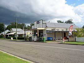
Vacy includes a public school, general store, oval, school of arts hall, the Farmers Hotel, a motel, "Eaglereach" resort, a hairdressing salon, post office, cafe, and a church.
Gilbert Cory, the son of John Cory developed the Vacy estate after his first marriage to Jeanette Rens. He lived there for the remainder of his life.
The rural nature of Vacy is demonstrated in the work of farmers managing beef cattle, dairy cattle, sheep, poultry and equine establishments, as well as other residents, retirees and working families with hobby farms and small acreages.