
District Český Krumlov Website www.vplane.ois.cz Elevation 695 m | Postal code 382 32 Area 4.79 km² Local time Wednesday 5:56 PM | |
 | ||
Weather 10°C, Wind W at 3 km/h, 63% Humidity | ||
Jal v ovat pl n
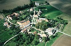
Věžovatá Pláně is a village and municipality (obec) in Český Krumlov District in the South Bohemian Region of the Czech Republic.
Contents
Map of 382 32 V%C4%9B%C5%BEovat%C3%A1 Pl%C3%A1n%C4%9B, Czechia
The municipality covers an area of 4.79 square kilometres (1.85 sq mi), and has a population of 121 (as at 28 August 2006).
Věžovatá Pláně lies approximately 9 kilometres (6 mi) south-east of Český Krumlov, 23 km (14 mi) south of České Budějovice, and 146 km (91 mi) south of Prague.
In 2003 a Czech-Austrian information and training center for solar power was founded in Věžovatá Pláně. That same year major Josef Mach claimed that the electricity from the Temelín nuclear power plant in the Czech Republic would be abandoned.
References
Věžovatá Pláně Wikipedia(Text) CC BY-SA