
Country Norway District Lofoten Area rank 428 in Norway Population 748 (2011) Official language form Bokmål | County Nordland Administrative centre Sørland Demonym(s) Værøyværing Administrative center Sørland | |
 | ||
Area 18.53 km² (18.49 km² Land / 4 ha Water) | ||
Paragliding norway v r y vaeroy island camel power club crocodile
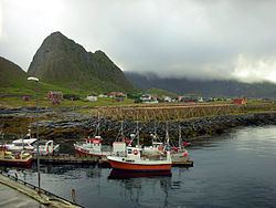
Værøy is an island and municipality in Nordland county, Norway. It is part of the traditional district of Lofoten. The administrative centre of the municipality is the village of Sørland. The other village in Værøy is Nordland. Most of the residents live in the Sørland area surrounding the main harbor. The old Værøy Lighthouse sits at the end of that harbor.
Contents
- Paragliding norway v r y vaeroy island camel power club crocodile
- Map of VC3A6rC3B8y Norway
- Midnight sun festival v r y 2014 norway psy trance
- General information
- Name
- Coat of arms
- Churches
- Geography
- Climate
- Government
- Municipal council
- Transportation
- Tourist attractions
- In literature
- References
Map of V%C3%A6r%C3%B8y, Norway
Midnight sun festival v r y 2014 norway psy trance
General information
The municipality of Værøy was established on 1 January 1838 (see formannskapsdistrikt). On 1 July 1928, the southern district of Værøy (population: 731) was separated to become the new municipality of Røst.
Name
The Old Norse form of the name was Veðrøy. The first element is veðr which means "weather" (here referring to harsh weather and the exposed and unsheltered position of the island). The last element is øy which means "island". Historically, the name has been spelled Værø.
Coat-of-arms
The coat-of-arms is from modern times; they were granted on 10 July 1988. The arms show a puffin on a blue background. Puffins nest in large numbers in the area and used to be of great importance for the village, both for meat and down.
Churches
The Church of Norway has one parish (sokn) within the municipality of Værøy. It is part of the Bodø deanery in the Diocese of Sør-Hålogaland.
Geography
The island municipality is made up of many islands, the two largest islands being Værøya and Mosken. It is located at the end of the Lofoten archipelago. The Norwegian Sea lies to the northwest and the Vestfjorden lies to the southeast. The Moskenstraumen maelstrom lies to the north between Værøy and Moskenesøya.
Climate
The weather in Værøy can be very changeable. Sunshine, rain, wind, and mist may interchange rapidly. The winter climate is mild and the temperature seldom drops below 0 °C (32 °F). This makes conditions for stockfish exceptionally good.
Røst and Værøy are famous with meteorologists, as they are the most northern locations in the world where there is no meteorological winter, as the average temperature is mostly above freezing all winter. The winter temperatures in southern Lofoten represent the highest temperature anomaly in the world relative to latitude due to the Gulf Stream from the Caribbean Sea. However the winter weather is rather windy and damp, so it does not feel so mild.
Government
All municipalities in Norway, including Værøy, are responsible for primary education (through 10th grade), outpatient health services, senior citizen services, unemployment and other social services, zoning, economic development, and municipal roads. The municipality is governed by a municipal council of elected representatives, which in turn elect a mayor.
Municipal council
The municipal council (Kommunestyre) of Værøy is made up of 13 representatives that are elected to every four years. Currently, the party breakdown is as follows:
Transportation
Helicopter transport is available from Bodø at the Værøy Heliport in Sørland. There was airplane service at Værøy Airport, but it was discontinued after the Værøy accident in 1990 in which five people lost their lives. The airport was determined to be in a bad position, due to the location next to a mountain and the frequent presence of strong and unpredictable winds, which made takeoffs and landings dangerous. Ferry service is also available from Bodø, Moskenes, and Røst.