Suvarna Garge (Editor)

Várkerület

Updated on
Edit
Like
Comment
Share on FacebookTweet on TwitterShare on LinkedInShare on Reddit
Country
  
Hungary

District
  
District I

ZIP Code prefix
  
1011 ... 1016

Area
  
3.41 km²

City
  
Budapest

Established
  
1873

Website
  
[1]

Population
  
24,933 (2015)

Várkerület httpsuploadwikimediaorgwikipediacommonsthu

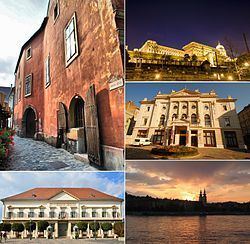
Várkerület is the historical part of the Buda side of Budapest and consists of the Buda Castle Hill and some other neighbourhoods around it, like Tabán, Krisztinaváros and parts of Gellért Hill.

Contents

Map of Budapest, District I., Hungary

Location

The Castle District is situated on the banks of the Danube, in the Buda side.

Neighbours of District I are (clockwise from north):

  • river Danube
  • District XI: Újbuda ("New Buda"), which is most known of the universities and student life
  • District XII: Hegyvidék ("Highlands")
  • District II
  • Landmarks

  • Buda Castle
  • Matthias Church
  • Hungarian National Gallery
  • Castle Hill Funicular
  • Sándor Palace
  • Fisherman's Bastion
  • Labyrinth of Buda Castle
  • Gellért Hill
  • Twin towns

  • District I of Vienna, Austria
  • Capestrano, Italy
  • Carouge, Switzerland
  • Lendava, Slovenia
  • Marlow, England
  • District I of Prague, Czech Republic
  • District I of Bratislava, Slovakia
  • Regensburg, Germany
  • Székelyudvarhely, Romania
  • Zenta, Serbia
  • References

    Várkerület Wikipedia


    Similar Topics