
Native name 浦内川 Length 19 km Mouth East China Sea | Main source 311.7 m (1,023 ft) Basin size 54.24 km (20.94 sq mi) Basin area 54.24 km² | |
 | ||
Discharge Average rate:120 m/s (4,200 cu ft/s) | ||
Japan trip exploring nature via urauchi river cruise iriomote island okinawa01
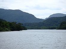
The Urauchi River (浦内川, Urauchi-gawa) flows through the central portion of the island of Iriomote in the Yaeyama District in Okinawa Prefecture, Japan. It is the longest river in Okinawa.
Contents
- Japan trip exploring nature via urauchi river cruise iriomote island okinawa01
- Map of Urauchi River Japan
- References
Map of Urauchi River, Japan
References
Urauchi River Wikipedia(Text) CC BY-SA