
Elevation 2,100 m | ||
 | ||
Similar Karaurín‑tepui, Wadakapiapué‑tepui, Uei‑tepui, Chimantá Massif | ||
Upuigma-tepui, also known as El Castillo, is a tepui in Bolívar state, Venezuela. A relatively isolated peak, both it and nearby Angasima-tepui lie just south of the vast Chimantá Massif, from which they are separated by the Río Aparurén valley. Upuigma-tepui is situated entirely within the bounds of Canaima National Park.
Map of Upuigma-tepui, Bol%C3%ADvar, Venezuela
The imposing peak of Upuigma-tepui has an elevation of around 2,100 metres (6,900 ft). Its highly uneven summit is dotted with numerous rock towers and deep crevasses which make it practically impossible to traverse. Summit vegetation is predominantly in the form of tepui scrub and dense stands of herbaceous plants. The mountain has a summit area of 0.63 km2 (0.24 sq mi) and an estimated slope area of 13 km2 (5.0 sq mi).
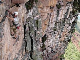
The first people to climb Upuigma-tepui were John Arran, Ivan Calderon and Steve Backshall, in 2007. Upon reaching the summit, they discovered several previously unknown species of plants and animals.