
OS grid reference TQ295869 Sovereign state United Kingdom Dialling code 020 | Postcode district N19 | |
 | ||
Upper holloway bridge demolition and replacement
Upper Holloway is a district in the London Borough of Islington, London, centred on the A1 Holloway Road.
Contents
- Upper holloway bridge demolition and replacement
- Upper holloway bridge replacement
- Toponymy
- Urban development
- Media
- References
Upper holloway bridge replacement
Toponymy
Upper Holloway is the original designation of the N19 postal district and the term is still used by the Royal Mail.
Urban development
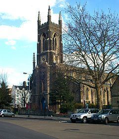
Upper Holloway was one of several hamlets within the ancient parish of St Mary Islington. As the population of the parish was increasing, the Church of St John Upper Holloway was built to meet local need, using the provisions of the Church Building Act 1818. It was consecrated in 1828 and in 1830 a new ecclesiastical parish was created, beginning the subdivision of the parish of Islington for this purpose.
The area around Hornsey Road was traditionally known as Tollington. This name has largely fallen out of use except for as the name as an electoral ward on the local council.
Media
The classic late Victorian comic novel Diary of a Nobody is set in Upper Holloway. The BBC's BBC Doomsday Project has some content for this area here:. Digital Public art project landscape-Portrait asked respondents about themselves and their area. The responses below relate to the postcode N19 4EH which is in Tollington ward in Upper Holloway.