
Country India Region Malabar, Tulu Nadu Time zone IST (UTC+5:30) Elevation 9 m Literacy 91% | State Kerala District Kasargod PIN 671322 Area 25.04 km² Area code 04998 | |
 | ||
Uppala (Malayalam:ഉപ്പള, Kannada: ಉಪ್ಪಳ ) is a major town in Kasaragod district, Kerala, India. Uppala is the satellite town for Kasaragod city.
Contents
- Map of Uppala Kerala
- Kasargod uppala accident 4 died manorama news
- Location
- Geography
- Climate
- Demographics
- Civic administration
- Air
- Road
- Rail
- Sea
- Economy
- Hospitals
- Schools and education
- Utility services
- References
Map of Uppala, Kerala
Kasargod uppala accident 4 died manorama news
Location
Uppala is located midway between Kasaragod and Mangalore. It is around 22 km north to the Kasaragod town and 24 km south to Mangalore city. Uppala is located about 586 km north to the state capital, Thiruvananthapuram. National Highway 66, which used to be known as NH 17, passes through the town. Uppala used to be known as Kurchipalla.
According to census, the town has a population of 41,212 with the density around 1650 per square kilometre.
As Uppala is located very near to the Arabian sea, it has a very low elevation of nine metres. The town is densely populated near the National Highway 66.
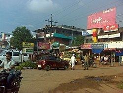
Uppala is a major infrastructural hub in the district and is noted for jewellery shops, fast food restaurants and high residential flats which lies across the town. High rises can be seen in town. It is the major destination for retail shopping in the district. Many projects are active in the town. It is also a major business hub in the district and also contributed for the rise in remittance in the state, in the most prevalent sectors like real estate, infrastructure, financial institutions, hospitality and healthcare.
The locals speaks many languages such as Malayalam, Tulu, Hindi, Urdu and Kannada. It has been selected as the centre of Urdu language in the region.
Geography
Uppala is the taluk headquarters of Manjeshwaram Taluk, which was carved out from Kasaragod taluk. Uppala town belongs to Mangalpady Gram panchayat. Geografical coordinates of Uppala are: 12° 68' 0" North, 75° 54' 0" East.
Uppala lies in the western cost of south India, between the Western ghats and the Arabian sea. Uppala River is also known as Kalai River, originates from the Veerakamba Hills in Karnataka. Uppala river enters Kerala through Manjeshwar thaluk(Uppala) in Kasaragod and finally ends near Uppala Gate. The length of the river is about 50 km. The Uppala River originates at about 150 m height from the sea level. Uppala river constitutes about 50 square kilometres in Kasaragod district. Hence it is the second largest river in the district after Shiriya river (60 km2). Mangalpady river, which flows near Bandiyod, is another river in Uppala.
Uppala is the neighbouring town for Kumbla, Manjeshwar, Paivalike, Puttur, Vittal, Kasaragod and Mangalore.
As of Census 2011, Uppala has a total area of 25.04 km2 and population around 41,000, which is densely located on the sides of NH 66.
Suburbs of town include places like cherugoli(mangalpady) Deenar Nagar, Uppala Gate, Hanafi Bazar, Nayabazar, Moosodi, Kondevoor, Kodibail, Songal, Kodanga, Pathwadi, Mulinja, Mannamkuzhi, Bappaithotti, Hanuman nagar, Manimunda, Kaikamba (Bombay Bazar), Turti, Bhagavathi, Kuntupuni, vikram bazar, Hidayath Bazar, Hidayath Nagar(HN), Pachilampara, Kuntupuni, Hajimalang Road, Bekoor, Kubanoor and kedakkar.
Climate
Uppala has a tropical climate. In most months of the year, there is significant rainfall in Uppala. There is only a short dry season and it is not very effective. The Köppen-Geiger climate classification is Am. The average annual temperature in Uppala is 27.1 °C. About 3801 mm of precipitation falls annually.
The driest month is January with 1 mm. Most precipitation falls in July, with an average of 1178 mm.
The warmest month of the year is April with an average temperature of 29.2 °C. In July, the average temperature is 25.9 °C. It is the lowest average temperature of the whole year.
The difference in precipitation between the driest month and the wettest month is 1177 mm. The average temperatures vary during the year by 3.3 °C.
Demographics
As of 2011 census, total population of Uppala is 41,212 with 17,093 males and 18,728 female population. Town has an area of 23.04 square kilometer and the population density about 1,650 per square kilometer. It has a literacy rate around 91 percent and has a population of 5,743 children below six years. Hence 14 percentage of total population are of below 6 years age. There is a steady growth in the town population in the past few years. People in Uppala speak many languages including Malayalam, Tulu, Kannada and Urdu. See the List of temples and mosques in Uppala
Civic administration
Uppala is a Taluk headquarters of Manjeshwaram Taluk, Kasaragod. Taluk office is at Main Junction, Uppala. Some other important government institutes in Uppala are Village office, which is in Nayabazar, Mangalpady Panchayath office at Nayabazar, Fire and Rescue station at Ambar, Community Health Center at Nayabazar, AEO'S Office, Uppala Post office, Mangalpady Post office, Krishi Bhavan at Ambar and Veterinary hospital at Ambar.
Uppala also has K.S.E.B. on Pathwadi road, Kerala Water Authority Pump House at Cherugoli, Cultural centre and library at Nayabazar, Lion's Club at Nayabazar, Govt Kerosene Supply bunk at Ambar.
Air
The nearest airport to Uppala is Mangalore International Airport, which is around 37 km away from the town. Kannur International Airport, which is 143 km from the town is under construction. Other airports near Uppala is Calicut International Airport, lies about 225 km to the south and Mysore Airport, which is around 255 km to the south east.
Road
Uppala is situated on NH-66, has a bus station and have minute to minute bus facility to Kasaragod and Mangalore. Uppala is well connected by road to Mangalore, Udupi, Manipal, Puttur, Kasaragod, Kannur, Calicut, Kochi and Thiruvananthapuram. As a satellite town, Uppala is well connected to Mangalore city by road.
Uppala-Bayar road connects Uppala with Paivalike, Bayar and leads to Kanyana, Vittal and Puttur in Dakshina Kannada district, Karnataka. Uppala bus station also provides buses to Puttur via Paivalike, Uppala to Badiyadka, Heroor and many other places. Buses which moves from Mangalore to Thiruvananthapuram stops in Uppala Bus Station. Taxy facilities are available in the town. There are a few no. of auto sheds in the town, from where you can catch autorickshaws.
Rail
Uppala has a railway station, westside from the heart of the town, where both the passenger and Express trains stops. Most of the students and workers travels daily by train to Mangalore from Uppala. Uppala is connected to Mangalore, Kasaragod, Kanhangad, Kannur,Kottayam, Thrissur, Ernakulam, Trivandrum, Coimbatore, and many other towns and cities by railway.
Sea
New Mangalore Port, is the nearest seaport to Uppala, which is around 33 km to the north. State Government have planned to construct a port capable of 275 boats in Moosodi near Manjeshwar.
Economy
Uppala is the destination for an hundred thousand shoppers in the district. Shop category mainly includes fashion, jewellery, food, automobile and many more.
Apart from shopping, Uppala also got many private education centres, and it is the education hub for a 50K population.
Uppala is also home for many national level builders but the town lacks the basic infrastructure like four laned road, proper two laned road connectivity with neighbouring places, footpaths, a better railway station or municipality status due to lack of educated government leaders.
Hospitals
Uppala has a government hospital at Nayabazar. Private hospitals in Uppala are KNH Hospital at Uppala railway station road, Health Care Center Uppala, Icon hospital, National nursing home at NH 66 (Late Dr. Iddinkunhi), recently hospital has been demolished, and Medicare center. And one more hospital in Bombay Bazar (also known as Kaikamba), Society Hospital, located in Uppala-Bayar Road.
Schools and education
Apart from marketing and business, this town also have one of the finest education centres in the district. These centres serves education for more than twenty thousand students in the region. Majority of the students here does 10th grade from these centres and favours colleges in Mangalore for their higher education.
Syllabus offered in these centres till the high school includes Kerala State Syllabus, and C.B.S.E. Apart from these high schools, town also witnesses many 3rd grade colleges offering degrees. See the list of Education Centeres in Uppala
One of the oldest schools founded in the 1980s, the Ayyoor Jamath Islami (A.J.I.) School by Late Umar Moulavi, who with the help of his well wishers endeavored to build the school at that time, has become one of the main and important educational institutions in this region. Another school is Aji Senior Secondary School.
Utility services
Electricity in Uppala is regulated by the Kerala State Electricity Board (KSEB). Uppala experiences scheduled and unscheduled power cuts, especially during the summer, due to excess consumption demands.
DTH services available in Uppala are Dish TV, Tata Sky, Sun Direct DTH, Airtel digital TV, Reliance BIG TV and Videocon D2h. Prominent broadband internet service providers in the town include Tata, Airtel and DataOne by BSNL. Town also accesses radio from the All India Radio tower at Kadri, Mangalore. Mangalore editions English language newspapers such as Times of India, The Hindu, The New Indian Express and Deccan Herald are available in the town. Local Malayalam and Kannada newspapers are also available.
Uppala has couple of beaches including Uppala Beach, Moosodi Beach and fishing zone, Ayyoor-Parakkatta Beach, Ayyoor-Peringady beach and Berika Beach..