
Population 701 | Sovereign state United Kingdom Dialling code 01404 | |
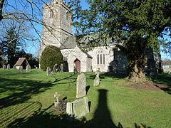 | ||
Upottery (originally Up Ottery) is a small village, civil parish and former manor in East Devon, England. It is situated in the valley of the River Otter, from which it derives its name. The northern boundary of the parish lies on the border between Devon and Somerset. Clockwise from there it is surrounded by the Devon parishes of Yarcombe, Stockland, Cotleigh, Monkton, Luppitt and Clayhidon. Parts of the parish church of St Mary the Virgin date from the 12th century. The United Kingdom Census 2011 recorded the population of the parish as 701. Upottery lies in the electoral ward of Otterhead which had a population at the United Kingdom Census 2011 of 2,201.
Map of Upottery, Honiton, UK
The former World War II airfield of RAF Upottery is located near the village.
References
Upottery Wikipedia(Text) CC BY-SA