Population 590 (2004 Est.) Post town GLASGOW Local time Sunday 5:30 PM | OS grid reference NS434552 Sovereign state United Kingdom Postcode district G78 Dialling code 01505 | |
 | ||
Weather 11°C, Wind SW at 21 km/h, 60% Humidity Lieutenancy areas East Renfrewshire, Renfrewshire | ||
Neilston uplawmoor first responders save a life for scotland
Uplawmoor is a village in East Renfrewshire, Scotland. Population 590 (2004).
Contents
- Neilston uplawmoor first responders save a life for scotland
- Map of Uplawmoor Glasgow UK
- Clyde property firwood 6 glen lane uplawmoor g78 4df
- Transport
- References
Map of Uplawmoor, Glasgow, UK
Historic Uplawmoor, associated for centuries with the Barony of Caldwell and the Mure family, is still a vibrant community today, although now bereft of many of the services once to be found there. Farming has always been of great importance locally.
Historically the village was served by two railway lines - Lanarkshire and Ayrshire and Glasgow, Barrhead and Kilmarnock Joint Railway
The Pollick Glen and burn is a local wildlife site of beech dominated woodland with a path network and a waterfall or spot.
The old hamlet of Shillford lies nearby on Lochlibo Road.
Clyde property firwood 6 glen lane uplawmoor g78 4df
Transport
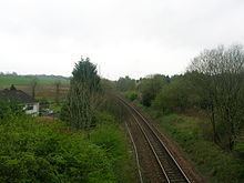
Caldwell station opened on 27 March 1871. The station was renamed Uplawmoor after the closure of the Uplawmoor station on the Lanarkshire and Ayrshire Railway on 2 April 1962. The station closed permanently on 7 November 1966. A number of local campaigns to re-open the station have so far been unsuccessful. It has now become overgrown and only a platform remains to show that Uplawmoor actually had a railway line.
