
Max. width 40 km (25 mi) Surface elevation 575 m Length 250 km | Max. length 250 km (160 mi) Surface area 6,256 km (2,415 sq mi) Area 6,256 km² Width 40 km | |
 | ||
Primary inflows Inflow source Lualaba River, Lufira River | ||
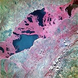
Upemba Depression or Kamalondo Depression which is more commonly known by its French name Dépression de l'Upemba is a large marshy bowl area (depression) in the Democratic Republic of the Congo comprising some fifty lakes, including 22 of relatively large size including Lake Upemba (530 km²) and Lake Kisale (300 km²). In an earlier era, the area was probably occupied by one large lake.
Map of Upemba Depression, Democratic Republic of the Congo
The area is covered in marshland and is partially within the Upemba National Park in Haut-Lomami District.
The Upemba Depression has been populated almost continuously since the 5th century AD, and is considered the origin of the Kingdom of Luba (1585-1889). The area includes many archaeological sites and is on the tentative list for UNESCO world heritage site.
Roughly translated, the citation for its inclusion as world heritage site states:
This large depression has delivered the largest known cemetery in the sub-Saharan Africa. Over 40 archaeological sites have been identified, but only six have been partially excavated so far. Their study allows to trace the complete sequence of the occupation of the region over two millennia, and thus to reconstruct the history of a major ethnic group of Central Africa: the Luba.