
Population 941 (1 Dec 2012) | Area 165.5 km² Local time Friday 12:06 PM | |
 | ||
Time zone Japan Standard Time (UTC+9) City hall address 443 Umaji, Umaji-mura, Kōchi-ken781-6201 Website www.inforyoma.or.jp/umaji/index.html Weather 8°C, Wind N at 29 km/h, 87% Humidity | ||
Umaji (馬路村, Umaji-mura) is a village located in Aki District, Kōchi Prefecture, Japan.
Contents
- Map of Umaji Aki District Kochi Prefecture Japan
- Geography
- Neighboring municipalities
- Education
- Access
- References
Map of Umaji, Aki District, Kochi Prefecture, Japan
As of December 1, 2012, the village has an estimated population of 941 and a density of 5.69 persons per km2. The total area is 165.52 km2.
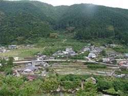
Geography
Umaji is located in a mountainous region, and the Yasuda River flows through. Approximately 96% of the village is covered by forests, 75% of which are protected by the government. Major mountains include Mount Eboshi (1,320 m) and Jinkichimori (1,423 m).
Umaji is part of the local area called Chugei 中芸 which includes Umaji, Yasuda, Tano, Nahari and Kitagawa.
Neighboring municipalities
Education
Access
Access is only by car or bus. Umaji's local train station is in Yasuda which is about a 30-minute drive away. Yasuda is on the Gomen-Nahari Line.
References
Umaji, Kōchi Wikipedia(Text) CC BY-SA