
Mexico Ind. 1821 Municipality Est 1921 Area 234.3 km² Area code 988 | Yucatán Est. 1824 Elevation 7 m (23 ft) Capital Umán | |
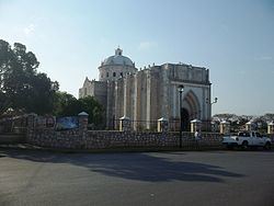 | ||
Umán Municipality (In the Yucatec Maya Language: “purchase”) is one of the 106 municipalities in the Mexican state of Yucatán containing (234.30 km2) of land and located roughly 15 km southwest of the city of Mérida.
Contents
- Map of UmC3A1n Municipality YucatC3A1n Mexico
- History
- Governance
- Communities
- Local festivals
- Tourist attractions
- References
Map of Um%C3%A1n Municipality, Yucat%C3%A1n, Mexico
History
There is no accurate data on when the town was founded, though it existed before the conquest and in antiquity belonged to the chieftainship of Ah Canul. At colonization, Umán became part of the encomienda system with Francisco Hernández recorded as one of the earliest encomenderos.
Yucatán declared its independence from the Spanish Crown in 1821 and in 1825, the area was assigned to the Lower Camino Real with its headquarters in Hunucma Municipality. In 1921, was designated as its own municipality.
Governance
The municipal president is elected for a three-year term. The town council has nine councilpersons, who serve as Secretary and councilors of heritage and sports, policing, education and health, public works, potable water, rural development and social management, roads and markets, nomenclature and recruiting, ecology, public monuments.
Communities
The head of the municipality is Umán, Yucatán. There are 87 populated areas of the municipality. The most notable include Bolón, Dzibikak, Dzununcán, Itzincab, Oxcum, Oxholón, Poxilá, San Antonio Mulix, Tebec, Xtepen, and Yaxcopoil. The significant populations are shown below:
Local festivals
Every year from 13 to 15 September the town holds a celebration for the Christ of Love.