
Primary outflows no egress Max. width 0.25 km (0.16 mi) Settlements Ulmen Shore length 900 m | Max. length 0.51 km (0.32 mi) Max. depth 37 m (121 ft) Surface elevation 440 m Cities Ulmen | |
 | ||
Primary inflows | ||
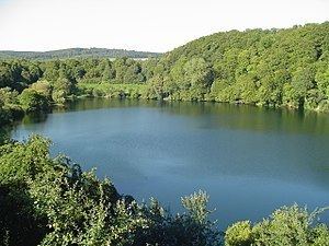
The Ulmener Maar is a maar in the Eifel mountains of Germany in the immediate vicinity of the town of Ulmen in the state of Rhineland-Palatinate. The lake is up to 37 metres deep and is surrounded by an embankment of tuff with an average height of 20 metres, which was formed from the erupted material of the former volcano. By the southern edge of the embankment are the ruins of a knight's castle, Ulmen Castle dating to the 11th century.
Contents
Map of Ulmener Maar, 56766 Ulmen, Germany
Literature
References
Ulmener Maar Wikipedia(Text) CC BY-SA