Years built 12th century Floor area 110 m² Material Granite | Length 20 m (66 ft) Province Leinster | |
 | ||
Previous denomination Pre-Reformation Catholic Similar Duiske Abbey, Blackstairs Mountains, Jerpoint Abbey, Mount Leinster, Irish round tower | ||
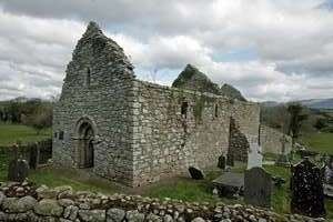
Ullard Church is a medieval church and National Monument in County Kilkenny, Ireland.
Contents
- Map of Ullard Church Ullard Borris Co Kilkenny Ireland
- Location
- History
- Church
- High cross
- Nearby
- References
Map of Ullard Church, Ullard, Borris, Co. Kilkenny, Ireland
Location
Ullard Church is located 700 m (2,300 ft) west of the River Barrow and 2.4 km (1.5 mi) south of Borris, County Carlow.
History
A monastery was supposedly founded on the site in the 7th century by either Saint Mo Ling or Saint Fiacre. A high cross was erected in the 9th century.
The stone church was built in the 12th century and the interior was greatly altered during the 16th century, with changes to the Romanesque doorway, the chancel widened and a stairway built into the wall. Around 1900 a Gaelic handball alley was built, using the church wall for one of the alley walls. This happened at other sites in southeast Ireland; a high stone wall is needed for the game, and several old castles or churches were used for handball.
Church
Ullard Church is a small nave-and-chancel church built of local granite with a Romanesque doorway. It originally had three orders but the inner order has been completely rebuilt. There is a crypt below the altar.
High cross
The cross stands about 4 m (13 ft) tall. It has a closed ring, typical of Barrow Valley crosses. Depicted upon it is the Crucifixion of Jesus, Adam and Eve, David with harp and the Binding of Isaac.
Nearby
In the field to the north of the Church are two bullaun stones nestled beneath a few trees. Further to the north is St Fiacre's holy well. Local people going abroad would bring a bottle of water from the well with them for good luck.
