
 | ||
A trip to the uist islands in the outer hebrides
Uist (/ˈjuːɪst/ or /ˈuːɪst/) or The Uists (Scottish Gaelic: Uibhist [ˈɯ.ɪʃtʲ]) are the central group of islands in the Outer Hebrides of Scotland.
Contents
- A trip to the uist islands in the outer hebrides
- Map of Uist UK
- Scotland harris lewis uist skye
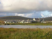
- Major settlementsEdit
- South UistEdit
- BenbeculaEdit
- North UistEdit
- GeographyEdit
- FishingEdit
- Land tenureEdit
- References
Map of Uist, UK
North Uist and South Uist are linked by causeways running via Benbecula and Grimsay, and the entire group is sometimes known as the Uists.
From south to north, the inhabited islands in the Uist group are Èirisgeigh (Eriskay), Uibhist a Deas (South Uist), Grimsay (South), Beinn nam Faoghla (Benbecula), Eilean Fhlodaigh (Flodaigh), Griomasaigh (Grimsay (North)), Fraoch-eilean, Uibhist a Tuath (North Uist), Am Baile Sear (Baleshare) and Beàrnaraigh (Berneray).
Scotland harris lewis uist skye
Major settlementsEdit
The main settlements in the Uists are:
South UistEdit
BenbeculaEdit
North UistEdit
GeographyEdit
Writing in 1549, Sir Donald Monro, High Dean of the Isles stated of "Ywst" that it was a fertile country full of high hills and forests on the east coast with five parish kirks. He also noted that in the north of "Ywst ther is sundrie covis and holes in the earth, coverit with heddir above, quhilk fosters maney rebellis in the countrey".
FishingEdit
Monro referred to the "infinite number of fresh water loches", including Loch Bì, which is South Uist's largest loch and at 8 kilometres (5.0 mi) long it all but cuts the island in two. Monro stated that "the sea has gotten enteries to this fresche water loche" and described the "thicke dyke of rough staines" that had been created to prevent salt water ingress. This apparently resulted in numerous fish being caught in the stones, including "fluikes, podloches, skatts, and herings" and he described another "kynd of fishe, the quhantitie and shape of ane salmont, but it has na skaills at all; the under haffe, narrest his vombe is quhite, and the upmaist haffe narrest his back is als black as jett".
Land tenureEdit
Monro's description was:
This countrey is bruiked by sundrey captains; to witt, the south southwest end of it, callit Bayhastill, be M’Neill of Barray, the rest of the ile, namit Peiter’s parochin, the parochin of Howes, and the mayne land of the mid countrey callit Mackermeanache, perteins to Clanronald, halding of the Clandonald. At the end heirof the sea enters, and cuts the countrey be ebbing and flowing through it: and in the north syde of this there is ane parochin callit Buchagla, perteining to the said Clandonald. At the north end thereof the sea cuts the countrey againe, and that cutting of the sea is called Careynesse, and benorth this countrey is called Kenehnache of Ywst, that is in Englishe, the north head of Ywst, whilk term is twa paroche kirks, and is mair of profit than the rest of haill of Ywst, perteining to Donald Gormesone.