
Mexico Ind. 1821 Municipality Est 1918 Area 196.7 km² | Yucatán Est. 1824 Elevation 28 m (92 ft) Area code 988 | |
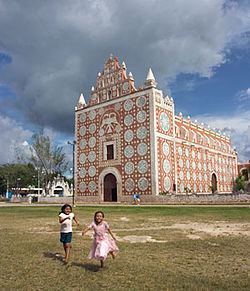 | ||
Uayma Municipality (In the Yucatec Maya Language: “water not here”) is one of the 106 municipalities in the Mexican state of Yucatán, containing (196.72 km2) of land and located roughly 165 km east of the city of Mérida.
Contents
- Map of Uayma YucatC3A1n Mexico
- History
- Governance
- Communities
- Local festivals
- Tourist attractions
- References
Map of Uayma, Yucat%C3%A1n, Mexico
History
There is no accurate data on when the town was founded, though it existed before the conquest and in antiquity belonged to the chieftainship of Cupules. At colonization, Uayma became part of the encomienda system with the first recorded encomendero as Juan Bellido 1549-1579. From him it passed to Martín de Güemes 1579; Gaspar González, Pedro de Valencia, and Pedro de Valencia II 1607; Francisco Menéndez Morán 1683-1688; and thereafter to Joaquin Menéndez.
Yucatán declared its independence from the Spanish Crown in 1821 and in 1825, the area was assigned to the partition of Valladolid Municipality. During the Caste War of Yucatán the city was abandoned but repopulated after federal troops regained possession of it. In 1918, it was designated as its own municipality.
Governance
The municipal president is elected for a three-year term. The town council has four councilpersons, who serve as Secretary and councilors of public works, education, nomenclature and public monuments.
Communities
The head of the municipality is Uayma, Yucatán. There are 16 populated areas of the municipality. The most notable, after the seat, include San Lorenzo, Santa María Aznar, and Xkatbe. The significant populations are shown below:
Local festivals
Every year on 3 May the festival of the Holy Cross is celebrated and on 15 May the feast of San Isidro Labrador, the town's patron saint is held. Also on 4 August a fiesta for Santo Domingo is recognized.