
Length 256.9 km | ||
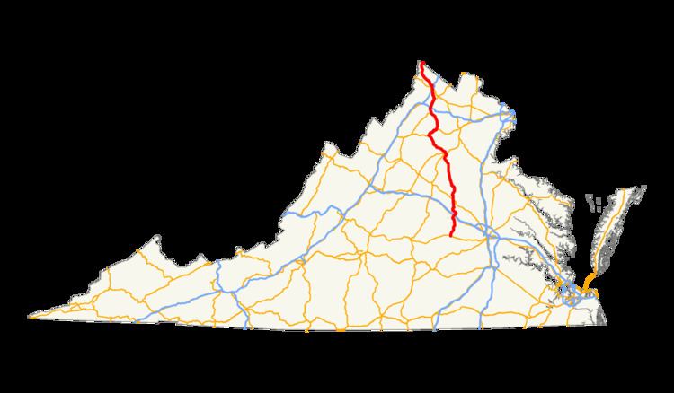 | ||
South end: US 60 / SR 1002 in Powhatan North end: US 522 near Cross Junction Counties Powhatan County, Virginia, Goochland County | ||
U.S. Route 522 (US 522) is a part of the U.S. Highway System that runs from Chase City, Virginia to Selinsgrove, Pennsylvania. In Virginia, the U.S. highway runs 159.65 miles (256.93 km) from its southern terminus at US 60 in Chase City north to the West Virginia state line near Cross Junction. In the Piedmont of central Virginia, US 522 is a minor highway connecting several county seats, including Powhatan, Goochland, and Culpeper. North of Culpeper, the U.S. highway increases in importance, crossing the Blue Ridge Mountains, connecting Culpeper with Sperryville and Front Royal. US 522 is mostly a four-lane divided highway north of Front Royal, where it passes through the Shenandoah Valley and the city of Winchester on its way to the Eastern Panhandle of West Virginia. The U.S. highway is part of the National Highway System from SR 37 near Winchester north to the West Virginia state line.
Contents
Piedmont
US 522 begins at an intersection with US 60 (Anderson Highway) in Powhatan. The roadway continues on the south side of the intersection as State Route 1002 (Emmanuel Church Road), which connects with SR 13. US 522 heads north as Maidens Road, passing through the countryside of Powhatan County before crossing the James River and CSX's James River Subdivision into Goochland County. At the hamlet of Maidens just north of the river, the U.S. highway intersects SR 6 (River Road) and joins the highway in a concurrency north through the village of Goochland, which is the unincorporated county seat of Goochland County. US 522 and SR 6 head north past the county offices and courthouse and the Goochland campus of J. Sargeant Reynolds Community College before splitting north as Sandy Hook Road where SR 6 (River Road) curves to the west toward Columbia.
US 522 continues north through the villages of Sandy Hook and Gum Spring, where the highway enters Louisa County. In Gum Spring, the U.S. highway intersects the local highway between Richmond and Charlottesville, U.S. Route 250 (Broad Street Road), and the express connection, I-64. US 522 heads north as Cross County Road, bridging the South Anna River and passing through Cuckoo, where the highway has a short concurrency with US 33, on its way to Mineral. North of Cuckoo, the highway's name is Pendleton Road until becoming Mineral Avenue in the town of Mineral, where the highway parallels CSX's Piedmont Subdivision. At the intersection with SR 208 and SR 22 (Piedmont Avenue), which head west toward the county seat of Louisa, US 522 and SR 208 turn east onto First Street, cross the railroad track, then turn north onto Louisa Avenue, which becomes Zachary Taylor Highway outside of the town limits.
US 522 and SR 208 head north toward Lake Anna, an impoundment of the North Anna River. At Wares Crossroads, SR 208 turns east toward Fredericksburg while the U.S. highway heads northwest, crossing the reservoir and passing through the southwest corner of Spotsylvania County before entering Orange County. US 522 heads straight north, passing to the east of Lahore before intersecting SR 20 (Constitution Highway) near Unionville. The U.S. highway veers northwest to cross the Rapidan River, entering Culpeper County, before returning to the north heading at Rapidan Road to parallel the railroad line to Culpeper. Just southeast of Culpeper, US 522 meets SR 3 (Germanna Highway), which it joins in a concurrency northwest to Culpeper. The two highways, which follow a four-lane divided highway, meet US 29 and US 15 (James Madison Highway) at a diamond interchange before entering the town of Culpeper, where the highway reduces to two lanes and crosses over the rail line. SR 3 reaches its western terminus at US 15 Business (Orange Road), which joins US 522 in a concurrency west to Main Street, which carries US 29 Business (Main Street). The U.S. highway and the two business routes head north through downtown Culpeper to Evans Street, where US 522 turns west.
Blue Ridge Mountains
US 522 heads north into the foothills of the Blue Ridge Mountains in western Culpeper County as Sperryville Pike. The U.S. highway passes through the village of Boston before entering Rappahannock. US 522 passes through a gap between Butler Mountain and Bessie Bell Mountain on its way to Woodville. The U.S. highway meets the northern end of SR 231 (T.F. Valley Road) before reaching the village of Sperryville. In Sperryville, US 522 joins US 211 (Lee Highway) in a concurrency. US 211 heads west toward Thornton Gap, where the highway crests the Blue Ridge Mountains and intersects Skyline Drive, the main highway through Shenandoah National Park, on its way to Luray in the Page Valley and New Market in the Shenandoah Valley. US 211 and US 522 head north as a four-lane divided highway, passing by the Rappahannock County seat of Washington, which is served by US 211 Business. East of Washington, US 211 continues east toward Warrenton while US 522 turns north toward Front Royal.
US 522 continues north as Zachary Taylor Highway, passing through the villages of Flint Hill and Huntly before ascending to Chester Gap, where US 522 crosses the Blue Ridge Mountains. The U.S. highway enters Warren County and descends to the town of Front Royal as Remount Road. US 522 intersects SR 55 (South Street), which heads west toward US 340 and the northern terminus of Skyline Drive and Shenandoah National Park. The U.S. highway continues north as Commerce Avenue, a four-lane divided boulevard, around the edge of downtown Front Royal before turning west and turning north onto Royal Avenue, on which US 522 joins US 340 and SR 55 in a concurrency. The three highways, which follow a four-lane undivided street, make a sharp turn to the west onto 14th Street, then make another sharp turn to the north onto Shenandoah Avenue before leaving the town limits by crossing the South Fork of the Shenandoah River and Norfolk Southern Railway's Hagerstown District.
Shenandoah Valley
At the village of Riverton just to the north of the South Fork, SR 55 (Strasburg Road) heads west toward Strasburg. US 522 and US 340 continue north as Winchester Road, crossing over Norfolk Southern's B-Line and the North Fork of the Shenandoah River just west of the confluence of the forks. The two highways expand to a four-lane divided highway head of a partial cloverleaf interchange with I-66. US 522 and US 340 pass by a variety of industrial properties and remain common until Double Tollgate in the southwest corner of Clarke County. US 340 heads northeast from the intersection as Lord Fairfax Highway toward Berryville, while SR 277 (Fairfax Pike) heads west toward Stephens City. US 522 enters Frederick County and continues northwest as Front Royal Pike through Armel and Parkins Mills and passes to the west of Winchester Regional Airport before reaching Winchester.
US 522 intersects US 50 and US 17 (Millwood Pike) just east of the city limits of Winchester. The north leg of the intersection are the northbound ramps to and from I-81. US 522 turns west onto Millwood Pike to join US 50 and US 17 in a concurrency. The three highways enter the city of Winchester as they pass under I-81 then meet the southbound ramps to and from the Interstate. After following Jubal Early Drive for a short distance while passing between the Apple Blossom Mall to the south and Shenandoah University to the north, US 522, US 50, and US 17 turn north onto Millwood Avenue and reduce to a two-lane street that meets CSX's Shenandoah Subdivision at grade. At the southern end of downtown Winchester, US 17 reaches its eastern terminus while US 522, US 50, and US 11 join in a one-way pair following Cameron Street northbound and Braddock Street southbound. US 522's portion of the one-way pair ends at Piccadilly Street, onto which US 522 turns at the western terminus of SR 7. US 522 heads west as a two-lane street, then makes a sharp turn north onto Fairmont Avenue and passes through an industrial area where the highway crosses a rail line. US 522 leaves the city limits as Frederick Pike and expands to a four-lane divided highway before meeting SR 37 at a diamond interchange. The U.S. highway passes through a series of short ridges on the western side of the Shenandoah Valley, including North Mountain, Hunting Ridge, and Timber Ridge. US 522 also passes through the communities of Albin, Nain, and Gainesboro. The U.S. highway intersects SR 127 (Bloomery Pike) near Cross Junction before reaching the West Virginia state line, where the highway reduces to two lanes, in the northwestern corner of Frederick County near the northernmost point in Virginia.