
Existed: 1935 – present Constructed 1935 | Length 170.6 km | |
 | ||
West end: US 44 in North East, NY East end: US 44 in West Glocester, RI Counties Litchfield County, Connecticut | ||
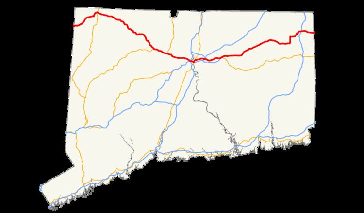
U.S. Route 44 (US 44) in Connecticut is a 106-mile-long (171 km) east–west U.S. Highway traveling from the New York state line in Salisbury to the Rhode Island state line in Putnam.
Contents
Route description
After entering the state from the town of North East, New York just east of the village of Millerton, US 44 is a rural arterial road. It is briefly duplexed with Route 41 for 1.67 miles through the center of Salisbury. After crossing into North Canaan, it is duplexed with US 7 for 0.33 miles through the village of Cannan. After leaving the village, it enters Norfolk, where it has a brief (0.34 mile) duplex with Route 272 in the center of town. After passing through the western part of Colebrook it enters the town of Winchester. As US 44 enters the village of Winsted, it begins a 2.14 mile concurrency with Route 183, 0.33 miles of which is joined by Route 8 in a triplex. At the east end of the village, Route 8 leaves to the south on an expressway, while Route 183 leaves to the south about 100 yards later. US 44 continues southeast through the towns of Barkhamsted, and New Hartford before entering Canton. In Canton, US 44 becomes a 4 lane primary suburban arterial road as it is joined by US 202 for a 4.3 mile concurrency to the center of Avon. As US 202 leaves to the north, US 44 is joined for the next 0.74 miles by Route 10. After climbing Avon Mountain, it enters West Hartford, passing along the northern part of the town and becoming an urban street as it entes the northern part of Hartford. After passing along Albany Avenue, and Main Street, US 44 turns east onto a pair of one-way streets (Morgan Street North and Morgan Street South) that straddle I-84 and US 6 and cross under I-91 with the only direct access being from Morgan Street South to I-91 South. US 44 then joins I-84 and US 6 for about 0.25 miles to cross the Connecticut River on the Bulkeley Bridge into East Hartford before exiting almost immediately onto Connecticut Boulevard. It briefly duplexes with US 5 on Main Street in East Harford center before turning east onto Burnside Avenue. After entering Manchester, it meets I-84 once again at Exit 60, and is joined in a concurrency for the next 7 miles by US 6, which leaves its I-84 concurrency at this point. The road then enters Bolton, where it meets the east end of I-384 at Bolton Notch. US 44 and US 6 briefly join the stub end of the expressway before US 6 splits off to the southeast. US 44 becomes more of a secondary rural road as it enters Coventry, where it briefly overlaps with Route 31. It then enters Mansfield, where it meets Route 195, which provides access to the University of Connecticut. After passing through Ashford, and Eastford, it turns north at Route 101 in Pomfret, which provides a more direct route to Providence. Shortly thereafter, Route 169 joins for a 2.25 mile concurrency to the center of town. US 44 once again turns east, and then enters the town of Putnam. After a 0.64 mile concurrency with Route 12, it meets I-395 at Exit 47. 4.66 miles to the east, US 44 crosses the Rhode Island state line into the town of Glocester
For most of its journey through Connecticut, US 44 is known as the Jonathan Trumbull Highway. It is also known by more local names, including Albany Turnpike in Canton, West/East Main Street and Avon Mountain Road in Avon, Albany Avenue through West Hartford into Hartford, Boston Turnpike from Bolton Notch to Ashford, and Providence Pike near the Rhode Island border.
History
Most of the alignment of modern US 44 in Connecticut was at one time part of an early network of turnpikes in the state during the 19th century. From the New York state line at Salisbury to the village of Lakeville, the route was the westernmost section of the Salisbury and Canaan Turnpike. Between North Canaan and New Hartford, modern US 44 was known as the Greenwoods Turnpike. The southeastward continuation of the Greenwoods road to the West Hartford-Hartford line was known as the Talcott Mountain Turnpike. From East Hartford to Eastford, the Boston Turnpike was chartered mostly along modern US 44 as the direct route from Hartford to Boston. The Boston Turnpike differed from modern US 44 by using a more direct route between Eastford and Pomfret Center along modern Route 244, while US 44 runs via the village of Abington. Past Pomfret Center, the Boston Turnpike diverged from modern US 44 heading northeast across the town of Thompson. The route through Putnam to the Rhode Island state line was a different turnpike road known as the Pomfret and Killingly Turnpike.
In 1922, the New England states designated route numbers on its main roads. Route 101 was assigned as the route used by the Pomfret and Killingly Turnpike (modern US 44) to Pomfret Center, then modern US 44 to Phoenixville via Abington (short portions of two other turnpike roads), then a road southward from Phoenixville to South Chaplin (modern Route 198), ending at New England Route 3. The direct road connecting Phoenixville to Bolton Notch was designated as Route 109. From Hartford to Bolton Notch, modern US 44 was at the time known as New England Route 3. West of Hartford, modern US 44 was designated as part of New England Route 17, which stretched in Connecticut from North Canaan to Stonington (via modern Route 2). Between the New York state line at Salisbury and North Canaan, the road was known as Route 121.
In 1926, most of New England Route 3 became U.S. Route 6. In the 1932 state highway renumbering, New England Route 17 was broken up into two newly assigned routes: modern Route 2 east of Hartford, and part of Route 101 west of Hartford. Route 101 was reconfigured in 1932 from its 1920s alignment to continue west of Phoenixville along former Route 109, then overlapping with US 6 to Hartford. Route 101 then used the western half of former New England Route 17 to North Canaan where it ended. The road from North Canaan to Salisbury was renumbered in 1932 to Route 199 to match the route number in New York at the time. In 1935, US 44 was designated and utilized Route 101 across the states of Connecticut, Rhode Island, and Massachusetts. Route 199 was also incorporated into the new route, connecting with the New York state line.
In the 1940s, US 44 was relocated along a portion of the Wilbur Cross Highway for several years with the former surface alignment becoming US 44A. The change was later reversed. US 6 was also relocated in East Hartford and Manchester to use I-84 and the overlap between US 6 and US 44 is now only between Manchester and Bolton Notch.