
Existed: 1931 – present Length 527.9 km | South end: Fort Fisher Constructed 1931 | |
 | ||
North end: US 421 / SR 34 at the Tennessee line Counties New Hanover County, North Carolina | ||
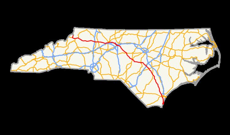
U.S. Route 421 (US 421) traverses approximately 328 miles (528 km) across North Carolina; from Fort Fisher, on Pleasure Island between the Atlantic Ocean and Cape Fear River, to the Tennessee state line near the community of Zionville. The highway is nominally labeled "north" and "south" throughout North Carolina, though it really follows a general northwest-southeast path, and the segment from Greensboro to Boone is almost due east-west, with compass west corresponding to the signed north direction.
Contents
- New Hanover County
- Down East
- Lee County to Randolph County
- Piedmont Triad
- Western Piedmont and Foothills
- The High Country
- History
- Future
- Junction list
- Alternate names
- References
A majority of the highway is part of the North Carolina Strategic Highway Corridors system. Because of this designation, the state has made numerous changes converting a rural two-lane highway into a major freeway/expressway with 4 or more lanes. Numerous former segments of the highway named "Old U.S. Route 421" are found along the entire route.
New Hanover County
US 421 starts at a parking/dock area on the Cape Fear side of Pleasure Island; within one-quarter mile (0.40 km), the Fort Fisher Ferry Terminal is located where travelers can ride a ferry to North Carolina Highway 211 (NC 211) and Southport. Immediately after the ferry terminal is the Fort Fisher State Recreation Area, where the first and second battles of Fort Fisher took place.
The highway continues north, going through popular tourist destinations in New Hanover county: Kure Beach, and Carolina Beach. US 421 eventually enters Wilmington along the river side of the city. At Wooster Street, it goes west, overlapping with several other highways and funnels through Brunswick County before returning in northwestern New Hanover County; there it links with Interstate 140 (I-140) before continuing north towards Clinton.
Down East
From about three miles (4.8 km) north of the I-140 interchange, the road remains a four-lane divided highway for another ten miles (16 km). After its intersection with NC 210, it becomes a rural two-lane highway for much of its remainder until Dunn. The exception is in Clinton, where it follows Faircloth Freeway to bypass the city, running concurrent to US 701 for about four miles (6.4 km). There is one rest area located just north of Delway. Most travelers in this corridor today use I-40, which parallels US 421 ten miles (16 km) to its east. Thus, it is unlikely that this section of US 421 will ever be upgraded as it has been throughout much of the state.
After crossing downtown Dunn and Erwin immediately to the east, US 421 becomes a four-lane divided highway again until reaching Lillington, with a short segment in Buies Creek containing a center lane and reduced speed limit as it crosses Campbell University. Upon reaching the junction with US 401, NC 27, and NC 210, all four routes collect onto a thoroughfare heading south over the Cape Fear River into downtown Lillington. US 421 then splits off to the west, becoming a two-lane expressway until Sanford (though speed limit never actually increases).
Lee County to Randolph County
Upon reaching Sanford, US 421 formerly followed Horner Boulevard with NC 87 to cross downtown, but it is now rerouted onto the recently completed Sanford Bypass, the entirety of which is freeway. It runs concurrent with NC 87 Bypass until the US 1/US 15/US 501/NC 87 interchange, from which it continues until the end of the bypass near Cumnock. The Sanford Bypass improves greatly upon the efficiency and consistency of the route between Greensboro and Fayetteville, and will alleviate heavy commercial traffic from Horner Boulevard and other major routes crossing downtown.
For the rest of its route until Greensboro, US 421 remains almost entirely free-flowing. It is an expressway from Sanford to just south of Siler City, bypassing Goldston, Bear Creek, and Siler City. From here to the Greensboro Urban Loop, US 421 becomes a freeway, bypassing Staley, Liberty, and Julian. All of these cities/places were connected by US 421's old alignment, now called some variant of Old US 421 for the majority of its route.
Piedmont Triad
Near Pleasant Garden, US 421 transitions from an expressway to a freeway by overlapping with I-85; it also goes west from this point until Sugar Grove. As the modern eight-lane I-85/US 421 overlap loops south of Greensboro, it soon connects with I-73 and switches to overlap it. Another six miles (9.7 km) later, it switches again to I-40 and continues on towards Winston-Salem. Near Kernersville, US 421 switches one last time with Business Loop I-40 going into downtown Winston-Salem. The freeway section through Winston-Salem is the oldest in the Triad and will typically have some construction for either road or bridge repair; people can bypass the downtown area by staying on I-40 then taking exit 188, where US 421 meets up again.
Western Piedmont and Foothills
At either exit 1 (via Business Loop I-40) or exit 188 (via I-40), US 421 separates toward Yadkinville. From Winston-Salem to Wilkesboro, US 421 continues on four-lane freeway, much of which was built between 1992-2002. This section of the highway is mostly farmland, with only Yadkinville as a viable place to stop for food and drink. When the highway nears North Wilkesboro, drivers will be able to see the North Wilkesboro Speedway (access via exit 282); there is also a visitor center built in 2009 as the state's first environmentally friendly rest area, located at mile marker 283. As US 421 enters Wilkesboro city limits, it downgrades to an expressway with various stores and restaurants along it. Travelers should anticipate higher traffic volumes between US 421 Business junction and NC 16 junction in Wilkesboro.
The High Country
As it leaves Wilkesboro, US 421 begins a gradual climbs up the Blue Ridge Mountains, until approximately five miles (8.0 km) from Deep Gap where it climbs up significantly. Compared to US 221 and US 321 that head towards Boone, US 421 is considered the safest by being the least steep and curvy route. Access to the Blue Ridge Parkway is located at Deep Gap, as US 421 continues on towards Boone.
As US 421 approaches Boone, the expressway comes to an end just before an intersection with Old US 421. The road continues into Boone as four lanes, dropping down to two lanes as it reaches the intersection with US 321. US 321 north, US 421 north, and NC 194 south all run concurrent through the downtown area via King Street. Traffic is typically bumper-to-bumper, so drivers can follow the US 421 truck route to the NC 105 Bypass (SR 1107) as an alternate to avoid the downtown area. Boone is also unique in that sister routes US 221 and US 321 connect at various points in town; however only the truck Routes of US 221, US 321, and US 421 join together as they overlap with NC 105 going southwest around town. After leaving Boone, US 421 continues on as a two-lane road to the Tennessee state line, heading on to Mountain City.
US 421 overlaps with two state scenic byways: the Cape Fear Historic Byway, in downtown Wilmington, and the U.S. 421 Scenic Byway, between Deep Gap and Boone. Two of North Carolina's Bicycle Routes run concurrent for portions of US 421. North Carolina Bicycle Route 5 is concurrent from US 421's southern terminus at Fort Fisher to north of Snows Cut, through downtown Wilmington to Blueberry Road near Montague, North Carolina, and a short portion near Coats. A small part of North Carolina Bicycle Route 3 is concurrent with US 421 in downtown Wilmington.
History
Future
In Kernersville, the roadway improvements and extension of Macy Grove Road will include the construction of a new interchange with I-40 Business/US 421. Property acquisition is to begin in 2012.
In Winston-Salem, shared with I-40 Business, a 1-mile (1.6 km) section from west of Fourth Street to east of Church Street has begun project development studies to completely upgrade and streamline. The project includes removing the existing pavement and replacing it with new concrete pavement, upgrade and modernize entrance and exit ramps, and replace most of the bridges on and over the freeway. No cost or time frame has been given at this time.
In New Hanover and Brunswick counties, the Cape Fear Skyway has begun its project development studies (since 2007) to build a toll road and bridge that will bypass Wilmington. Early estimates range from $950 million to $1.1 billion. The environmental impact study is expected to be completed in 2014, a record of decision and a complete financial feasibility will be done in 2015.
Junction list
Note – Exit numbers west of Winston-Salem are aligned when US 421 went north around Greensboro in late-1980s/early-1990s. As a result, from realignments in Greensboro, the actual mileage vs. exit number mileage is off by an average of 3.5 miles (5.6 km).
Alternate names
Though the highway is commonly known as "421" throughout the state, the highway does have other known names it uses locally in areas.