
Formed August 12, 2012 Fatalities 40 total | Dissipated August 18, 2012 | |
 | ||
Highest winds 10-minute sustained: 120 km/h (75 mph)1-minute sustained: 130 km/h (80 mph) Lowest pressure 970 hPa (mbar); 28.64 inHg Damage $262 million (2012 USD) Date 12 August 2012 – 18 August 2012 Similar Typhoon Tembin, Typhoon Vicente, Typhoon Saola, Typhoon Haikui, Typhoon Guchol | ||
Typhoon Kai-tak, known in the Philippines as Tropical Storm Helen, was a mild tropical cyclone that affected China, Vietnam and Laos. It was the seventh typhoon and the thirteenth named storm of the 2012 Pacific typhoon season. The storm killed up to 40 people and caused a sum of US$315 million in losses. Kai-tak can be tracked back to the broad area of disturbance embedded in a monsoonal trough that was first spotted, early on August 10. It was only at midnight, on August 16, when the JMA officially declared Kai-tak a typhoon. On the morning of August 17, the windpseed dropped to 60 knots (110 km/h; 69 mph) and was no longer a typhoon. The typhoon caused heavy damage in China's two provinces killing one person and causing a great economic loss. In Vietnam, Typhoon Kai-Tak has stormed across the country's north bringing high winds and floods to several areas including the capital Hanoi. Tropical Storm Kai-Tak slammed the northern Philippines triggering flash floods and landslides and killing at least three people, one week after deadly monsoon rains battered the country.
Contents
Meteorological history
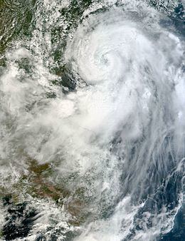
The origins of Kai-tak can be tracked back to the broad area of disturbance embedded in a monsoonal trough that was first spotted, early on August 10. By the next day, the convection deepened and a weak low-level circulation center was spotted with winds of up to 20 knots (37 km/h; 23 mph). A Tropical Rainfall Measuring Mission pass revealed that the convection around the system was very loosely organised and the banding was relatively weak. By midnight, that day, the Japan Meteorological Agency (JMA) started tracking the system as a weak Tropical Depression with winds under 30 knots. A couple of hours later, the Joint Typhoon Warning Center (JTWC) issued a Tropical cyclone formation alert (TCFA) estimating winds of up to 22 knots (41 km/h; 25 mph). As the storm was also in the Philippine Atmospheric, Geophysical and Astronomical Services Administration (PAGASA)'s area of Responsibility, they started issuing advisories on the system, thus naming it Helen. By noon, on August 12, the JMA confirmed that the depression has reached a windpseed of 30 knots (56 km/h; 35 mph). As opposed to this, in their first advisory on the system, the JTWC said that the storm had winds of up to 25 knots only. Only late that night, did the JTWC confirm winds of 30 knots, based on new microwave imagery and satellite data. The storm was moving to the west at 12 knots (22 km/h; 14 mph) at the moment. At midnight, the JMA reported winds of 35 knots (65 km/h; 40 mph), stating that the depression had intensified into a tropical storm, thus officially naming it Kai-tak. At 09:00 UTC, on August 13, the JTWC confirmed the same. At that time, the system had a broad, partially exposed low-level circulation center (LLCC) with deep convection persisting along the western periphery. Later the same day, according to JMA, the storm reached a maximum sustained windspeed of 50 knots (93 km/h; 58 mph), thus making it a Severe Tropical Storm.
The storm continued tracking northwestward and was located approximately 400 nautical miles (740 km; 460 mi) northeast of Manila, Philippines. Infrared imagery revealed that deep convection persisted along the southwestern periphery of the LLCC. Though the storm entered warm watered off the Philippine coast, it failed to intensify rapidly as it was located along the southern periphery of a deep-layered subtropical ridge and was experiencing moderate vertical wind shear. The JTWC did not expect the storm to strengthen any further since it would start interacting with the nearby landmass. On August 14, the LLCC of the storm passed under the deepest convection, however, it failed to intensity because an anticyclone that was located to the northeast of Kai-tak. Albeit the ample outflow, no good convection developed to the northern half of the system due to the shear caused by the anticyclone. At this moment, Kai-tak was expected to rapidly drift eastward due to the persistent subtropical ridge. The JTWC expected Kai-tak to become a typhoon within 48 hours due to warm sea-surface temperatures, and then make landfall. By the night of August 14, Kai-tak tracked westward at 06 knots (11 km/h; 6.9 mph) and the LLCC became embedded within central dense overcast convection. The storm became more consolidated as a result. Fragmented concentric deep convection surrounded the LLCC. Also, the anticyclone to the east of the system weakened thus reducing the wind shear affecting Kai-tak. The windspeed then rose to approximately 55 knots (102 km/h; 63 mph). By the next day, the Kai-tak accelerated towards the Philippines. The LLCC started interacting with the northern coast of the island nation. The deep convection continued to build along with the strong equatorward outflow. The storm, however, produced no poleward outflow. Due to the sudden rise in trackspeed, the JTWC estimated a landfall within 12 hours.
On the night of August 15, the infrared satellite imagery showed that convective bands have deepened and wrapped tighter into the LLCC and an excellent equatoward outflow. The windspeed was estimated at 65 knots (120 km/h; 75 mph), which is equivalent to a minimal category 1 tyhoon on the SSHS. Kai-tak was expected to continue intensifying before making landfall over China, and then decay rapidly due to land interaction. According to reports the next morning, Kai-tak continued drifting westward at about 13 knots (24 km/h; 15 mph). Though the bulk on convection remained to the southern semi-circle, deep convective rainbands have developed over the northern periphery. Over the past 12 hours, the storm rapidly moved west, into china and was expected to make landfall soon. Kai-tak was located along the southern periphery of a deep subtropical ridge positioned over southeast China. The storm continued speeding towards China and by the night of August 16, it was drifting west at nearly 14 knots (26 km/h; 16 mph). Infrared imagery showed that the cloud-top temperatures were starting to drop. The vertical wind shear near Kai-tak had weakened dramatically. However, the storm maintained the same windspeed. The JTWC announced that the storm would start weakening rapidly within 12 hours due to land interaction. It was only at midnight, on August 16, when the JMA officially declared Kai-tak a typhoon. By then, the system sped up towards landmass. It was drifting west at over 16 knots (30 km/h; 18 mph), poised to make landfall over the Leizhou peninsula over the next 12 hours, cross the Gulf of Tonkin, before making a second and final landfall into northern Vietnam to the east of Hanoi. At the same time, the PAGASA issued their last warning on Kai-tak, otherwise known as Helen, locally, as it left the Philippine area of Responsibility.
On the morning of August 17, Kai-tak made landfall over the Leizhou peninsula, as expected. It maintained the same intensity and was expected to track west-northwestward under the influence of the subtropical ridge. Within 6 hours, Kai-tak made a second landfall over the northeast coast of Vietnam and has weakened slightly. The windpseed dropped to 60 knots (110 km/h; 69 mph) and was no longer a typhoon. Kai-tak was expected to weaken rapidly thereafter. Later that night, the JTWC issued their final warning on the system as it weakened further and sped up inland. They expected the system to dissipate within 24 hours. However, the JMA stopped tracking the storm early the next morning, no longer considering it a tropical cyclone.
Hong Kong
On August 15, The Hong Kong Observatory issued the Standby Signal, No. 1 warning regarding Kai-tak as an advisory to the public to closely follow weather reports before flying. The next day, the observatory hoisted the Strong Wind Signal, No. 3 for strong wind, as the storm came within 500 km of the region. Later that evening, the Observatory announced that the storm would be closest to the city within 24 hours, skirting within 250 km, and forecasted winds of up to 62 kilometres per hour (39 mph). Hong Kong's flag carrier Cathay Pacific also announced that they will be temporarily suspending services to the region due to the typhoon. Hong Kong, which is the main hub of Cathay Pacific closed their airport for the next 24–48 hours in preparation for the system.
China
On August 15, The national disaster relief authority of China issued a fourth-level alert, predicting that the storm may hit the coastal areas of the provinces of Guangdong and Fujian. Warnings have been issued to the Pearl River Delta forecasting rainfalls up to 400 millimetres (16 in). The agency asked all ships to return to port, reinforce outdoor structures, and evacuate workers from offshore oil platforms.
Vietnam
On August 16, The Central Steering Committee for Flood and Storm Prevention and Control stated that preparations need to be made regarding the approaching storm. The committee asked all boats at sea to remain well informed about the storm. They predicted winds of up to 75 kilometres per hour (47 mph).
Philippines
Early on August 16, Tropical Storm Kai-Tak slammed the northern Philippines triggering flash floods and landslides and killing at least three people, one week after deadly monsoon rains battered the country, disaster relief officials said. Twenty northern provinces had been placed under storm warnings before the storm hit. The Office of Civil Defence said one man drowned when he suffered a seizure and fell into a flooded rice field in the province of Pangasinan and another drowned while crossing a swollen river on Tuesday in Ilocos Norte province. Another man died from electrocution in Naguilian town in nearby La Union province, said Superintendent Jovencio Badua, a regional police spokesman. At least 3,555 people were evacuated from their homes in La Union and Pangasinan because of flash floods while several highways were cut off because of landslides, Badua said. By that night, the storm left behind seven dead and two missing in the Philippines. The storm blew out of the Philippines offering some relief for millions of people struggling to recover from a few weeks of monsoon rains that earlier claimed 109 lives. But more than the death toll, a foreign organisation warned the floods posed a continuing and major problem to the three million people who were displaced from their homes, almost one million of whom had sought refuge in temporary evacuation centres. The NDRRMC said it was still providing relief aid to nearly a million people impacted by last week’s floods, including more than 216,000 at evacuation centres. “The need is massive and urgent, millions of people are suffering the miserable consequence of these floods and we must try to reach them before the rains hit again,” Anna Liendfors, the country representative of Save the Children appealed. At the same time, weathermen warned residents living in low-lying and mountainous areas against possible landslides and flash flood due rains ranging from heavy to intense. In Pampanga, the home province of former president Gloria Macapagal-Arroyo in Central Luzon, officials ordered the pre-emptive evacuation of residents in villages along one of the major river systems.
China
At about 12:30 am on August 17, Kai-tak made landfall at Huguang township in Guangdong province, bringing extreme downpours and gales. Off the eastern Zhanjiang coast, the violent weather triggered waves as high as four metres. In Zhanjiang city, trees and billboards could be seen scattered along the roads while most of the shops and restaurants remained closed. Hundreds of passengers were stranded at an airport in Beihai city in the Guangxi Zhuang Autonomous Region, after 16 flights linking Beijing, Shanghai, Kunming, and Changsha areas were cancelled. Sources from the Maritime Search and Rescue Center of Qinzhou city said, six people were still trapped after their ship was marooned in Qinzhou Port, Thursday evening. Helicopter, tugs and patrol boats were dispatched to the site for rescuing the trapped people, said the city authorities. According to fishery departments of the coastal cities of Beihai, Qinzhou and Fangchenggang, as of 1 p.m., more than 10,000 fishing boats had been called back to harbours for shelter, and over 40,000 fishermen and seafood farmers have gone ashore to avoid heavy rains, gales and waves. Elsewhere, the typhoon also led to delay and cancellation of 14 incoming flights and seven outgoing flights in Meilan International Airport, in Haikou, capital of the Hainan province. Also, in Hainan, where the heavy rains lashed, 23 flights had been cancelled and 18 others delayed at the Sanya Phoenix International Airport in Sanya City at 10:30 a.m., leaving 3,000 passengers helpless. Officials supervising flood control and drought relief efforts said relief materials and rescue personnel were fully prepared to mitigate the impact of Kai-Tak. In addition to airports, railways were affected. A total of 16 high-speed trains linking Sanya and Haikou were suspended. In Haikou, there were reportedly few pedestrians spotted in the city, where slow-moving cars were seen clogging the rain-hit roads. Officials supervising flood control and drought relief efforts said relief materials and rescue personnel were fully prepared to mitigate the impact of Kai-Tak.
As of August 18, more than 700 villagers in Qinzhou, a city in south China's Guangxi Zhuang Autonomous Region, have been trapped in their homes by typhoon-triggered flooding, the local government said. In Qinzhou, heavy rains have swept the city inundating three villages in Dazhi Township, Qinbei District. The local government sent rescue boats and relief materials to the trapped villagers. Two people remained missing after falling into a river in Shangsi County. More than 300 police officers and firefighters have been organized and dispatched to carry out relief efforts across the city, the flood control and drought relief bureau said. The typhoon caused heavy damage in China's two provinces killing one person and causing economic loss running into $315 million. It also affected 1.74 million people in nearby Guangdong province before moving to Guangxi. An oil ship anchored near Beihai, a coastal city in Guangxi, drifted and collided into the bank, spilling five tonnes of oil. The local government initiated an emergency response plan and sent a work team to clean up the spill and cordon off the contaminated area to prevent the pool from expanding. Clean up efforts have ended and marine authorities have taken samples of the sea water to test the pollution level around the location of the accident, the report said.
Vietnam
Meanwhile, in Vietnam, Typhoon Kai-Tak has stormed across the country's north bringing high winds and floods to several areas including the capital Hanoi. Among the victims was a taxi driver who was killed when a tree fell on his car in Hanoi, while two others died from electric shock after a cable fell in northern Son La city. Another victim died in a landslide. Earlier more than 11,000 boats, including several hundred used by tourists at Halong Bay, were ordered to stay close to the shore. The Vietnamese army put 20,000 soldiers backed by helicopters, rescue boats and canoes on standby to handle any incidents.