
Fatalities None Dissipated 4 January 1953 | Highest winds 295 km/h | |
 | ||
Formed December 27, 1952 (1952-12-27) Lowest pressure 950 hPa (mbar); 28.05 inHg Similar Typhoon Olive, Typhoon Gilda, Typhoon Agnes, Typhoon Bess, Typhoon Irma | ||
Typhoon hester 1952 top 6 facts
Typhoon Hester was a severe typhoon that formed in the 1952 Pacific typhoon season and continued into January 1953. As the twenty-ninth storm and twentieth typhoon of the season, it was first tracked by Joint Typhoon Warning Center (JTWC) near Marshall Islands as a tropical storm on December 27. Hester quickly became a typhoon and rapidly intensified. Near the end of the year, Hester became a Category 5 typhoon on the modern-day Saffir–Simpson hurricane wind scale south of Guam. The typhoon soon weakened quickly as it curved eastward and sped up. It weakened into a tropical storm on January 4, and JTWC ceased tracking it hours later.
Contents
In preparations for the storm, shelters were opened in Guam, and all government buildings and businesses were closed. In Marshall Islands, Enewetak experienced significant flooding, and buildings were damaged by the wind. Eighteen people were injured on the island. In Guam, the only damage reported were destroyed crops due to waves. There were no casualties caused by the storm.
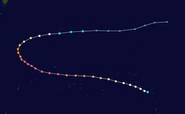
Meteorological history
Hester was first tracked by the JTWC at 1800 UTC of December 27, 1952. The storm was located southeastern Marshall Islands, and had winds of 100 km/h (60 mph). It soon intensified into a typhoon, with winds of 75 mph (120 km/h) at 0000 UTC of December 28. On the next day, Hester strengthened to 90 mph (145 km/h) west of Marshall Islands. The storm began to rapidly intensify, as it moved north of Micronesia. At 0000 UTC of December 30, Hester became a Category 5 typhoon on the Saffir–Simpson hurricane wind scale, with winds up to 160 mph (255 km/h). It soon peaked in intensity on the next day at 1200 UTC, just south of the Mariana Islands. The storm had winds at 185 mph (295 km/h) and began to turn northwest. On New Year's Day, the Japan Meteorological Agency (JMA) recorded Hester's lowest pressure of 950 millibars (950 hPa).
Hester began to weaken later that day, with winds down to 170 mph (275 km/h). By 0600 UTC of January 2, the winds lowered down to 150 mph (240 km/h), equivalent of a Category 4 typhoon. Hester began to curve eastward and began to weaken rapidly. On January 3, Hester continued to weaken to 110 mph (175 km/h), and eighteen hours later, it was down to 80 mph (130 km/h). It soon became a tropical storm on January 4, and soon dropped to a tropical depression later that day. JTWC ceased tracking the storm near Minami-Tori-shima.
Preparations and impact
In Guam, underground shelters were open to residents, and hospitals were evacuated by December 31. All government offices and businesses were closed on the island. Roadblocks were placed by the police to keep vehicles off the road. A gale alert was issued for the Mariana Islands. Four days later, shipping was warned for the area southeast of Formosa, as Hester approached the area.
The northwest quadrant of Hester passed over Enewetak at 5:13 p.m in Marshall Islands Time (5:13 a.m UTC) on December 28, 1952. The Navy estimated that Hester generated winds around 70 mph (110 km/h), and generated waves up to 30 feet (9.1 m) high on Enewetak. There were no direct reports on the island, where it was mostly underwater when the storm passed it. The hospital, mess halls, and clubs were damaged by the winds. Tents on the island were also destroyed. A Coast Guard LORAN station on the island suffered extensive damage. Overall, eighteen people were injured on Enewetak, and there were no casualties. Nearby atoll of Ujelang, received stronger winds than Enewetak, as it was closer to the center of Hester. Hester past south of Guam by 130 miles (210 km), and no damage to military facilities were reported. The only damage reported were crops being lashed by the waves on the south side of the island. There were no casualties on the island.