
Easiest route Paved road, hike Phone +1 415-831-6331 | Elevation 281 m Listing Nob Hill | |
 | ||
Topo map USGS San Francisco North Address 501 Twin Peaks Blvd, San Francisco, CA 94114, USA Hours Open today · Open 24 hoursMondayOpen 24 hoursTuesdayOpen 24 hoursWednesdayOpen 24 hoursThursdayOpen 24 hoursFriday(Cesar Chavez Day)Open 24 hoursHours might differSaturdayOpen 24 hoursSundayOpen 24 hoursSuggest an edit Similar Union Square, Fisherman's Wharf, Stonestown Galleria, Presidio of San Francisco, Jack London Square | ||
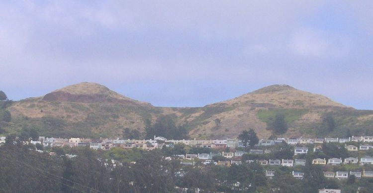
The Twin Peaks are two prominent hills with an elevation of about 925 feet (282 m) located near the geographic center of San Francisco, California. Only 928 foot (283 m) Mount Davidson is higher within the city.
Contents
Location and climateEdit
The North and South Twin Peaks, also known as "Eureka" and "Noe" respectively, are about 200 m (660 ft) apart; Twin Peaks Boulevard runs a figure eight around them. The peaks form a divide for the summer coastal fog pushed in from the Pacific Ocean. Their west-facing slopes often get fog and strong winds, while the east-facing slopes receive more sun and warmth. Elevation at each summit is just over 900 feet (270 m). Thin, sandy soil is commonplace on Twin Peaks, making them susceptible to erosion.
HistoryEdit
Before the arrival of the Europeans, the native Ohlone people may have used Twin Peaks as a lookout or hunting ground. The ecological diversity of Twin Peaks provided medicinal or ceremonial plants, grains and berries. When the Spanish conquistadors and settlers arrived at the beginning of the 18th century, they called the area "Los Pechos de la Chola" or "Breasts of the Indian Maiden" and devoted the area to ranching. When San Francisco passed under American control during the 19th century, it was renamed "Twin Peaks".
AttractionsEdit
Christmas Tree Point lies some 70 ft (21 m) below the North Peak and offers vistas of San Francisco and San Francisco Bay. The view to the north extends no farther than Cobb Mountain (38.807°N 122.741°W / 38.807; -122.741) 120 km away, but looking southeast down the Santa Clara Valley on a clear day, Santa Ana Mountain 36.8782°N 121.2637°W / 36.8782; -121.2637 is just visible 143 km away.
To the north is one of the city's many reservoirs. It is owned by the San Francisco Fire Department, and supplies water to the Fire Department's independent HPFS water system for fighting fires, established after the 1906 earthquake and fire.
The top of Twin Peaks is undeveloped. It is part of the 31 acres (13 ha) Twin Peaks Natural Area, managed and owned by the San Francisco Recreation and Parks Department. These preserved areas are home to many natural resources and wildlife. As part of the Mission blue butterfly habitat conservation, Twin Peaks is one of the few remaining habitats for this endangered species. Many bird species, insects and vegetation thrive in these areas.
The Muni Metro Twin Peaks Tunnel runs beneath Twin Peaks, linking Downtown San Francisco with West Portal and the southwestern part of the city. There is no public transportation all the way to the top of the Peaks, but the 37 Corbett Muni line stops on Crestline Drive near a path up the hill.
The San Francisco Police Department Academy is at the base of the peaks.
The name "Twin Peaks" is also applied to the surrounding neighborhood.