
Country Vietnam Capital Tuyên Quang Calling code 27 Area 5,867 km² Area code 27 | Region Northeast Time zone ICT (UTC+7) Website www.tuyenquang.gov.vn Population 746,700 (2013) ISO 3166 code Vietnam | |
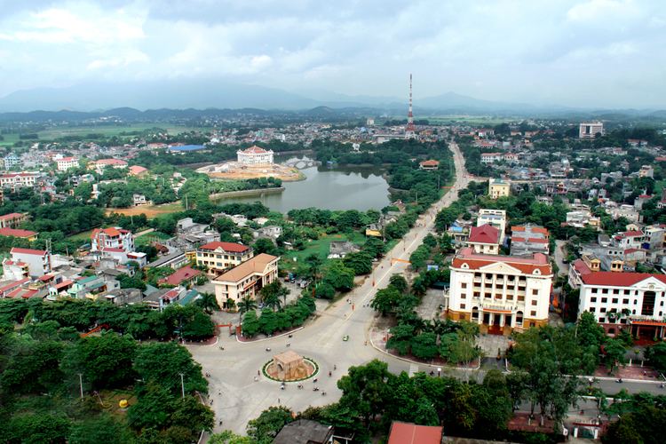 | ||
Tuyên Quang ( listen) is a province of Vietnam, located in the northeastern part of the country to the northwest of Hanoi, at the centre of Lô River valley, a tributary of the Red River. The delta formation in the province is called the Tonkin Delta. Its capital is Tuyên Quang township. The province had a population of 730,800 in 2011, with a density of 125 persons per km2 over a total land area of 5,867.3 square kilometres (2,265.4 sq mi).
Contents
- Map of TuyC3AAn Quang Vietnam
- History
- Geography and climate
- Water resources
- Administrative divisions
- Demographics
- Economy and development
- Economic indicators
- Tuyn Quang hydroelectric plant
- Forest
- Flora and fauna
- Historical places
- Festivals
- References
Map of Tuy%C3%AAn Quang, Vietnam
Tuyên Quang borders Hà Giang to the north, Cao Bằng to the northeast, Bắc Kạn and Thái Nguyên to the east, Vĩnh Phúc to the south, Phú Thọ to the southwest, and Yên Bái to the west.
History
Tuyên Quang, the capital city of the province has a rich history of the battles fought in the region. The earliest history is to the First Indochina War when it served as a garrison. During this war the Viet Minh made the Legionnaires surrender at the memorial to the Battle of Tuyên Quang. Another historical event is the Siege of Tuyên Quang, commemorated in the first verse of Le Boudin, its principal marching song. The French garrison posted at Tuyên Quang defended the town for four months against 12,000 troops of the Yunnan Army and the Black Flag Army. Two companies of the French Foreign Legion1 company of Tonkinese Tirailleurs, 31 naval gunners with four mountain guns, and eight sappers, commanded by Sergeant Bobillot, plus the gunboat Mitrailleuse. were involved during the Sino-French War (August 1884 to April 1885).
Tuyên Quang was once entirely settled by Thai people, but from the 13th century onwards were integrated into the Trần Dynasty, who named it Quốc Oai before naming it Châu Tuyên Quang. Under the rule of Emperor Trần Hiến Tông (reigned 1329–1341), Tuyên Quang was given the status of a trấn, before being categorised a thành phủ when the Ming Dynasty of China briefly annexed Vietnam at the start of the 15th century. After Lê Lợi expelled the Chinese and started the Lê Dynasty, he made Tuyên Hóa a part of Tây Đạo. During the reign of Emperor Lê Thánh Tông, Tuyên Quang comprised one phủ and five districts (huyện) and became the province of Minh Quang under the rule of Emperor Lê Uy Mục. During the reign of Lê Trang Tông, Minh Quang became An Tại, and control of the region was given to the Vũ family, ethnic Thai people.
By the end of the 17th century, the Lê Dynasty sent ethnic Vietnamese officials to the area to supervise the Thais. After Gia Long started the Nguyễn Dynasty, he changed the region to the trấn of Tuyên Quang, and it became a province under the rule of his successor Emperor Minh Mạng. When the French carried out their colonial conquest, the phủ of Yên Bình was at the forefront of the resistance movement. People from the Thái, Mường, Mèo, Thổ, Nùng and another ethnic groups engaged the French in many battles in the area in 1884–85. The Black Flags were also prominent. It was not until 1894 that the French had pacified the region. Prior to 1975, the province comprised the districts of Yên Sơn, Yên Bình, Hàm Yên, Sơn Dương, Chiêm Hóa and Đại Thi.
Geography and climate
The province has widely varying topography covering high mountains deep valleys; the dominant elevation of the province is in the range 200–600 metres (660–1,970 ft). The province is in the foothills of the Northern Highlands, which forms a broad crescent around the Tonkin Delta; its southern part has narrow river basins and mountain ranges (elevation below 300 metres (980 ft)) and the northern part, particularly in Chiêm Hoá and Nà Hang districts the slopes are steep with hills taller than 1,400 metres (4,600 ft) (the highest mountain is Cham Chu at 1,589 metres (5,213 ft)). The Tam Dao range is located in this province.
In the southern part of the province, about 100 kilometres (62 mi) away from Hanoi as the crow flies, is the provincial capital, also bearing the name of the capital city of the province, Tuyên Quang has an elevation below 100 metres (330 ft) located on the right bank of the Lô River, a tributary of the Red River which rises at Hà Giang, near the Chinese border. Its major tributary is the Gâm River on its left bank. The province has a land area 5,900 square kilometres (2,300 sq mi). The province's territory has only 7.2% of natural forest comprising both rain forest and monsoon forest.
Water resources
The distribution of river and stream network in the province is 0.98 km/km2. There are three main rivers: Lô, Gâm and Pho Day. The Lô River originates in Van Nam, China, flows through Hà Giang to this province; it flows for a length of145 kilometres (90 mi) in the province and drains an area of 2,090 square kilometres (810 sq mi). Its maximum flow is 11,700 m3/s, while the minimum flow recorded is 128 m3/s. It is a navigable river and is a major water route of the province to carry goods to other provinces. The second major river is the Gâm, which originates in China and flows through Cao Bằng and Hà Giang, before entering Tuyên Quang. The Gâm joins the Lô at Tu Hiep. The river flows for 170 kilometres (110 mi) length in the province darining an area of 2,870 square kilometres (1,110 sq mi). The next major river of importance is the Pho Day River which rises in the Tam Dao Mountains in Bắc Kạn Province. It traverses 84 kilometres (52 mi) in the province through Yên Sơn, Sơn Dương District to Phú Thọ, and has a drainage area of 800 square kilometres (310 sq mi). The navigation possibilities of this river are very limited. In addition to the three major rivers, there is an abundance of small rivers, lakes and ponds (2000 ponds). The total volume of surface water available from all these sources is estimated at 10 BCM. River water is potable, clear and tasteless, has a pH value ranging from 6.5 and 7.5. The underground water resources of the province, according to preliminary assessments done in the past, was about 3,500,000 m3/ngd. The water is potable with low mineral content. In addition, the province has three mineral water sources: two hot and one cool.
Administrative divisions
Tuyên Quang is subdivided into 7 district-level sub-divisions:
They are further subdivided into 5 commune-level towns (or townlets), 129 communes, and 7 wards.
Demographics
According to the General Statistics Office of the Government of Vietnam, the population of Tuyên Quang province as of 2011 was 730,800 with a density of 125 persons per square kilometre over a total land area of 5,867.3 square kilometres (2,265.4 sq mi) of the province. The male population during this period was 369,100 with females accounting for 377,800. The rural population was 676,200 against an urban population of 70,700.
Economy and development
The province's economy is dependent on its primary industries. In 2005, the economic breakdown is as follows: construction 30.7%, services 33.6%, agriculture, forestry and fishery 35.7%. Rice is the staple food. Also grown are maize, cassava, potato, tea, lemongrass and citrus fruits, as well as beans. Livestock includes buffalo, pigs and poultry. The most important mineral reserves are zinc ore, manganese ore, tin and antimony. The province is also a producer of paper, cement and limestone.
The land economy is dependent on the agricultural growth in the province, which is dependent to a land area of 1,051 square kilometres (406 sq mi)) under agriculture, about 20% of the province. However, this has also caused deforestation. However, the practice of shifting cultivation called the "swidden agriculture"(practiced by ethnic minorities) is limited to 3000 ha, as in 1992, and is said to be reducing under a UNDP funded project; has covered the aquaculture development in ponds. However, the Lô River which flows through the province has much potential for development of aquaculture.
The province has 900 villages in upland areas, which are inhabited mostly by impoverished ethnic minorities. Under an IFAD funded project for Rural Development (IFAD loan:US$20.9 million), agricultural training has been provided to the farmers on pilot plots to teach them to adopt new practices and techniques in the field of agriculture, animal husbandry, credit, food storage and processing that are appropriate for the local environment. In addition, infrastructure, health services and village level institutions like the savings and credit groups, user groups and village development boards have also been supported by this funding. The forestry sector of the economy is influenced by the Bai Bang pulp and paper mill, said to be one of the largest in Vietnam, located in the adjoining Vinh Phu Province. It was established in the 1980s with financial help from Sweden. Commercial logging is carried out in the plantation forests by the state-sponsored enterprises to supply pulp to the factory.
Economic indicators
As against the national figure of 7,592 agriculture, forestry and fishery cooperatives, there are only 147 agriculture cooperatives in the province (142 are farming and 6 are fishery cooperatives). There are 54 farms in the province compared to the national number of 120,699.
The output value of agricultural produce at constant 1994 prices in the province was 959.5 billion đồngs, compared to the national value of 156,681.9 billion dongs. The province produced 569,400 tonnes of cereals as against the national production of 324,200 tonnes.
The per capita production of cereals in the district was 434.1 kilograms (957 lb) as against the national figure of 501.8 kg in 2007. In 2007, the industrial output of the province was a meagre 1102.7 billion đồngs against the national output of 1.47 million billion dongs.
Tuyên Quang hydroelectric plant
The Tuyên Quang Hydropower Plant, also known as Dai Thi, is a major hydroelectric power project located within the province on the Gam River near Pac Ta Mountain. Construction began on December 22, 2002 and the first unit was commissioned in March 2008 followed by the two other units by end of 2008. The power plant has a capacity of 342 MW (the second largest in the north), and has an energy generating potential of 1200 GWh/year. The project's estimated approved cost was US$490 million. The project, as built, has a 92 metres (302 ft) rock fill dam and 718 metres (2,356 ft) long (crest length), called the Na Hang Dam. It has a gross storage capacity of 2.3 billion cubic metres (BCM) (including 1 BCM of flood storage) on the Gâm River.
Forest
Cultivated land including permanent cropland are mainly in the south of the province. The large closed forest is typical of the northern districts and is widespread in about 12% of the area. Bamboo forests are present recorded in all districts of the province, except Na Hang. The area of forests have reduced due to conversion into agricultural land or because they have become barren. However, this reduction could not be exactly correlated to the changes in the biodiversity of the province.
Flora and fauna
The province has a rich range of flora and fauna. Data compiled for the province has recorded flora from 90 families, 258 classes, and 597 species, and many of them are listed as endangered. The Vietnamese Red Book lists 18 scarce and precious plants in the province including aloe wood, pantace vietnamiensis, textured wood, limestone vatica, hoang dan and abony-tree.
There are 293 faunal species, of which there are 51 animal species belonging to 19 families; there are 175 bird species of 45 families; there are 5 reptile species and 17 amphibian species from 5 families. The animal species are found in abundance, although 39 animal species are listed in the scarce and precious category. Fauna in danger of extinction comprise 18 species of animals, 12 species of birds, 12 species of reptiles and one species of amphibian. The six mammal species particularly identified in the area are the tiger, the Asian black bear, the clouded leopard, the Indian muntjac (a small cervine), black gibbon, the apricot panther, the sambar (another small cervine) and the Sumatran serow (a small caprine). The primates identified are the Tonkin snub-nosed monkey and Phayre's leaf monkey; the last named is reported to be extinct. The habitat of the mammals, including primates, is stated to be shrinking due to deforestation and expansion of agricultural activities.
Historical places
Historical places in the province include the Cave Pagoda at Yên Sơn; the Dat Nong Tien and the Thuong Temple in Tuyên Quang. The natural beauty of the province is provided by the mountain ranges with peaks exceeding 2,000 metres (6,600 ft), and the My Lan Spring. There are 26 registered historical monuments, eight cultural centres and 42 communal cultural houses in the province. The predominant Christian churches in the province are the seven Roman Catholic churches; 60% of the province is believed to be Catholic.
Festivals
The popular festivals celebrated in the province are the Gieng Tanh village festival and the Qua Tang festival of the Dao people.