
Population 1,225 2011 Census Local time Monday 2:17 AM | OS grid reference SP943525 Sovereign state United Kingdom Dialling code 01234 | |
 | ||
Weather 4°C, Wind NE at 11 km/h, 90% Humidity | ||
Turvey is a village and civil parish on the River Great Ouse in Bedfordshire, England, about 6 miles (9.7 km) west of Bedford. The village is on the A428 road between Bedford and Northampton, close to the border with Buckinghamshire. The 2011 Census recorded the parish's population as 1,225.
Contents
Map of Turvey, Bedford, UK
History
Turvey is recorded in Domesday Book of 1086 as a parish in the Hundred of Willey. There are eight separate entries for Turvey, including a total of 44 households. The Mordaunt family obtained the manor by marriage in 1197 and were ennobled as Barons of Turvey in the 16th century. The Mordaunt family house, Turvey Old Hall, was replaced by Turvey House in 1792, by which time the estate had passed to the Higgins family. It was extended in the 19th century and still stands. There is a second large house in the village called Turvey Abbey, which was historically a family house, but is now a Benedictine monastery.
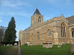
The Church of England parish church of All Saints has Saxon origins but is almost certainly a post-Norman building. It is the largest church in the deanery of Sharnbrook and was in the Diocese of Lincoln until it was transferred to the Diocese of Ely in 1837. Since 1914 it has been in the Diocese of St Albans. It has a 13th-century door with its original ironwork, a Norman baptismal font, a wall painting of the crucifixion and some notable monuments, including monumental brasses.
Turvey has a strong history of lace-making: there is evidence of a 19th-century lace-making school.
In the 19th century the Bedford to Northampton Line of the Midland Railway was built through the parish and opened in 1872. There was a Turvey railway station in Station Road about 1 mile (1.6 km) east of the centre of the village. British Railways closed the line in 1962.
Public houses
Amenities
Turvey has a village store and post office, village hall and two public houses: the Three Fyshes and The Three Cranes. There is long-established pre-school, Turvey Pre-School Playgroup, that looks after children from 2 years old and also runs a Before and After School Club for children at the local school. Turvey Lower School is a school for children from reception (4 years old) to year four (9 years). The Warren Nursery is a nursery for children from 6 weeks to 5 years.
Transport
Stagecoach in Bedford bus route 41 bus between Bedford and Northampton serves the village.
Population
The population of Turvey was 758 in 1801, rising to 1,028 in 1851 and falling to 782 by 1901. In 1951 it had dropped further to 733 but rose to 1,043 by 1991.
Turvey electoray ward includes the villages of Stagsden and Kempston Rural. Its borough councillor is Mark Smith (Conservative).