
Easiest route hike Elevation 3,340 m Mountain range Cordillera Central | Last eruption 7 December 2016 Age of rock 1.500995 million years Parent range Cordillera Central | |
 | ||
Similar Irazú Volcano, Poás Volcano, Arenal Volcano, Rincón de la Vieja Volcano, Barva Volcano | ||
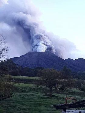
Turrialba Volcano is an active volcano in central Costa Rica that has been explosively eruptive in recent years including 2016 and in January, 2017. Visitors used to be able to hike down into the main crater, but increased volcanic activity in 2014-16, resulting in large clouds of volcanic ash, has caused the surrounding Turrialba Volcano National Park to close.
Contents
- Map of Turrialba Volcano Cartago Province Turrialba Costa Rica
- Activity
- March 2015
- May 2015
- May 2016
- September 2016
- References
Map of Turrialba Volcano, Cartago Province, Turrialba, Costa Rica
The stratovolcano is 3,340 m (10,958 ft) high and is about 45 minutes from the Atlantic slope town of Turrialba. The summit has three craters, the largest of which has a diameter of 50 m (160 ft). Below the summit is a mountain range and montane forest, with ferns, bromeliads, lichens and mosses. Most of the forest is either primary or secondary forest.
Turrialba is adjacent to Irazú and both are among Costa Rica's largest volcanoes. Turrialba has had at least five large explosive eruptions in last 3500 years. On clear days both the Pacific Ocean and Caribbean Sea can be seen from the summit.
The volcano is named after its canton, Turrialba, in Costa Rica's Cartago Province. There is no clear consensus on the origin of the name Turrialba, but historians disagree with attempts to attribute the name to the patronym Torrealba (from Aragon in Spain) or from the Latin Turris alba (white tower). The general consensus is that Turrialba derives from the local Indian (Huetar language), but there is no agreement on its actual roots.
This volcano is monitored by the Deep Earth Carbon Degassing Project.
Activity
March 2015
May 2015
May 2016
An eruption occurred on May 21, 2016. It was characterized by one resident as the largest since 2010. Ash fell as far away as the capital, San Jose, and at least 500 people went to hospitals complaining of breathing problems. Flights into San Jose were cancelled due to concerns about ash.
September 2016
On September 19, at 02:54 an eruption lasting around fifteen minutes was the first event of many through the day that eventually covered the metropolitan area with ash. There were events at 11:30, 14:40, 15:34.
The events continued through September 20 with an eruption at 06:20.
Airports in the metropolitan area were closed.