
Status municipality Time zone EET (UTC+2) Population 22,268 (2011) | First attested 1387 Area 107.2 km² Local time Monday 2:40 AM | |
 | ||
Weather 3°C, Wind N at 5 km/h, 95% Humidity Team ACS Sporting Turnu Măgurele | ||
Turnu m gurele 54 gro e walachei rum nien romania 17 4 2016
Turnu Măgurele ([ˌturnu məɡuˈrele]) is a city in Teleorman County, Romania (in the informal region of Wallachia). Developed nearby the site once occupied by the medieval port of Turnu, it is situated north-east of the confluence between the Olt River and the Danube.
Contents
- Turnu m gurele 54 gro e walachei rum nien romania 17 4 2016
- Map of Turnu MC483gurele Romania
- Hingherul dolana din turnu m gurele
- Geography
- History
- Tourist attractions
- Economy
- References
Map of Turnu M%C4%83gurele, Romania
Hingherul dolana din turnu m gurele
Geography
A ferry plies across the Danube to the Bulgarian city of Nikopol. There are some vestiges of a Roman bridge across the Danube, built in 330 by Constantine the Great. It is built in the Danube plain in a fertile land called Burnas plain. At 4 km south-west from it the river Olt joins the Danube. Its medium altitude is 33 m above sea level.
History
The name of the city means "Hill Tower" in Romanian, in reference to the defense-wall tower of a fort built on the spot by Byzantine Emperor Justinian I in 6th century (ruins of the facilities can still be seen).
Bulgarians maintained in this place a fortress named Holavnik. The town was occupied by the Ottoman Empire in 1417, towards the end of Prince Mircea I's rule, and, like Giurgiu and Brăila, constituted a kaza on the left bank of the Danube, under the name Kule. With short interruptions during the anti-Ottoman rebellions of Vlad III the Impaler and Michael the Brave, destroyed by Iancu Jianu's hajduks in their campaign against Osman Pazvantoğlu and his successor (1809) and never rebuilt under Turkish rule, Turnu, like the other two kazas, was due to be returned to Wallachia through the 1826 Akkerman Convention - and was ultimately ceded in 1829, through the Treaty of Adrianopole. It became the capital of Teleorman County in 1839.
The village of Islaz, near Turnu Măgurele, was the initial center of the 1848 Wallachian revolution (see Proclamation of Islaz). During the Romanian War of Independence, the town served as a base for the campaign in Bulgaria. After the administrative reform of 1968, it became a municipality.
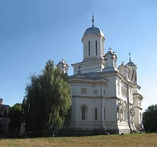
Tourist attractions
The major tourist attraction is Saint Haralambios Cathedral in the center of the town. Built by Greek farmers at the beginning of the 20th century, the cathedral is based on the plans of Curtea de Argeş Cathedral and constructed in a late renaissance style. Another city landmark is the independence monument. It was built in celebration of the major role that Turnu Măgurele played in the Romanian Independence War (1877-1878).
Economy
A chemical and textile industry (MTM, Manufactura Turnu Măgurele) center in the past, the city has more recently been diversifying its economy (ElectroTurris - a diesel engine factory, and ConservTurris - a food processing plant).
The chemical plant is notorious for the air pollution (issued gases contain ammonia and hydrogen sulfide in times above the norms), and it quite possibly does not meet the EU ecological (air pollution) requirements.