
15th century–1920 → Established 15th century 1910 55,703 | Capital Turócszentmárton 1910 1,123 km (434 sq mi) | |
 | ||
Turóc (Hungarian, historically also spelled Túrócz), Slovak: Turiec, Latin: Thurotzium/comitatus Thurociensis, German: Turz) was an administrative county (comitatus) of the Kingdom of Hungary. Its territory is now in north-western Slovakia, where the corresponding Slovakian name Turiec is only an informal designation of the corresponding territory.
Contents
Geography
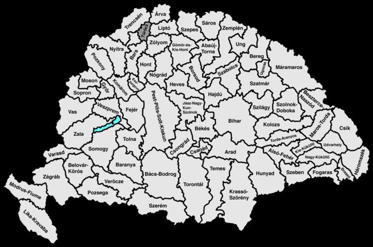
Turóc county shared borders with the counties of Nyitra, Trencsén, Árva, Liptó, Zólyom and Bars, situated between the Lesser Fatra (Kis-Fátra) and Greater Fatra (Nagy-Fátra) Mountains. The river Turóc flowed through the county. Its area was 1123 km² around 1910.
Capitals
The capitals of the Turóc county were the Szklabinya Castle and Turócszentmárton (present-day Martin; Slovak name until 1950: Turčiansky Svätý Martin); from 1772 only Turócszentmárton was the capital.
History
Turóc county as a Hungarian comitatus arose before the 15th century. In the aftermath of World War I, the area of the now defunct Turóc county became part of newly formed Czechoslovakia, as recognized by the concerned states in 1920 by the Treaty of Trianon. The territory of the county is now part of Slovakia.
1900
In 1900, the county had a population of 51,956 people and was composed of the following linguistic communities:
Total:
According to the census of 1900, the county was composed of the following religious communities:
Total:
1910
In 1910, the county had a population of 55,703 people and was composed of the following linguistic communities:
Total:
According to the census of 1910, the county was composed of the following religious communities:
Total:
Subdivisions
In the early 20th century, the subdivisions of Turiec county were: