
Airport type Public Elevation AMSL 14 ft / 4 m 1,778 542 Code TNK | 8/26 1,778 Elevation 4 m Phone +1 907-269-0747 | |
 | ||
Owner State of Alaska DOT&PF - Central Region Address Yukon Delta National Wildlife Refuge, Tununak, AK, USA | ||
Tununak Airport (IATA: TNK, FAA LID: 4KA) is a state-owned, public-use airport located one nautical mile (1.85 km) southwest of the central business district of Tununak, in the Bethel Census Area of the U.S. state of Alaska.
As per Federal Aviation Administration records, this airport had 1,809 commercial passenger boardings (enplanements) in calendar year 2008, a decrease of 9.6% from the 2,001 enplanements in 2007. Tununak Airport is included in the FAA's National Plan of Integrated Airport Systems (2009–2013), which categorizes it as a general aviation facility.
Although most U.S. airports use the same three-letter location identifier for the FAA and IATA, this airport is assigned 4KA by the FAA and TNK by the IATA.
Facilities
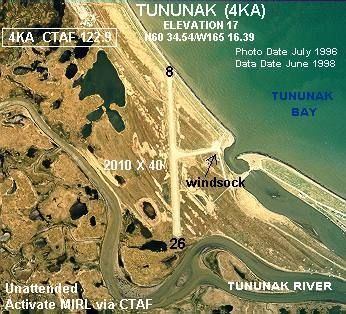
Tununak Airport has one runway designated 8/26 with a gravel surface measuring 1,778 by 30 feet (542 x 9 m). The airport is unattended.
Remarks: