
OS grid reference TA305319 Postcode district HU12 Dialling code 01964 | Post town HULL Local time Sunday 2:50 PM | |
 | ||
Weather 9°C, Wind NE at 16 km/h, 75% Humidity | ||
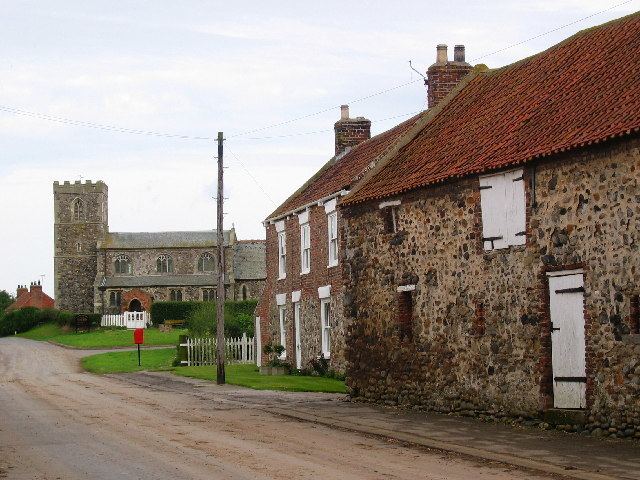
Tunstall is a village in Holderness, in the East Riding of Yorkshire, England, close to the North Sea coast.
Contents
Map of Tunstall, Hull, UK
Geography
Tunstall village is located in the civil parish of Roos in Holderness, in the East Riding of Yorkshire, England. It is situated approximately 3 miles (4.8 km) north-west of the town of Withernsea, and less than 0.6 miles (1 km) from the North Sea coast, at a height of 10 to 15 m (33 to 49 ft) above sea level, and close to the Greenwich Meridian.
The coast at Tunstall is eroding at an average rate of 1.1 to 2 m (3 ft 7 in to 6 ft 7 in) a year.
To the south-east of Tunstall is a 126 acres (0.51 km2), 550 pitch caravan holiday park, Sand le Mere Holiday Village.
History
Tunstall was recorded in the Domesday Book as "Tunestal", within the manor of Withernsea. The church of All Saints was originally of Norman construction, with many later alterations in the 13th and 14th centuries, primarily of beach cobble with stone dressings; a tower was added in the 15th century.
A number of buildings in the village date to the early 18th century, including the cobble-built Town Farmhouse, Manor Farmhouse and nearby barn. The brick-built Hall Farmhouse was constructed in the later 18th century, An enclosure act for the land around the village was passed in 1777. The Kings Arms public house dates back to at least the 1850s.
In 1823 inhabitants in the village numbered 163. Occupations included eight farmers, two shopkeepers, a tailor, a corn factor, and the landlady of the Cock public house. A carrier operated between the village and Hull on Tuesdays. Tunstall was close to the coastal Sand le Mar, an area frequented by neighbouring village inhabitants collecting sand and pebbles for the repair of roads.
During the anti-invasion preparations of the Second World War a number of fortifications were constructed near Tunstall, including: a minefield north of the village, a weapons pit, several coastal pillboxes, and tank traps.
After the end of the Second World War, one of the pillbox structures was re-used as a nuclear explosion monitoring post (Royal Observer Corps Monitoring Post) during the Cold War period.
The Greenwich meridian was marked by a re-sited trig point in 1999; the marker fell into the sea in 2003 as a result of coastal erosion.
Governance
Tunstall forms part of the civil parish of Roos and is represented locally by Roos Parish Council while at county level is in the South East Holderness ward of the East Riding of Yorkshire Council. At a parliamentary level it is part of the Beverley and Holderness constituency which is represented by Graham Stuart of the Conservative Party. While at European level it is in the Yorkshire and the Humber constituency.