
Country Philippines Barangays Area 467.3 km² Province Isabela | Founded 1751 Time zone PST (UTC+8) Local time Sunday 6:44 PM | |
 | ||
Region Cagayan Valley (Region II) District 1st District of Isabela Weather 26°C, Wind NW at 6 km/h, 82% Humidity | ||
Mangi festival 2017 tumauini isabela inter school drum lyre competition
Tumauiniis a 1st class municipality in the province of Isabela, Philippines. According to the 2015 census, it has a population of 67,650 people.
Contents
- Mangi festival 2017 tumauini isabela inter school drum lyre competition
- Map of Tumauini Isabela Philippines
- St matthias parish tumauini isabela
- Geography
- History
- Barangays
- Local Government
- Economy
- Attractions
- San Matias Parish Church
- Camp Samal
- Mangi Festival
- References
Map of Tumauini, Isabela, Philippines
Tumauini is classified as partly urban with an average 117.79 people are living on one km².
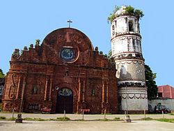
St matthias parish tumauini isabela
Geography
Tumauini is located at the northern portion of the province of Isabela. Its land area is 46,730 hectares (115,500 acres) or 5.62% of the total land area of Isabela. It is bounded on the north by the municipality of Cabagan and 68 kilometres (42 mi) south from Tuguegarao (the Regional Center); on the east by the municipality of Divilacan, on the south by the City of Ilagan, the capital of Isabela (30 kilometres (19 mi) away) and 445 kilometres (277 mi) north from Manila; on the west by the Cagayan River and the municipality of Delfin Albano.
History
The name of Tumauini originated from the name of the big trees found in the poblacion called “Mauini”. It is said that when some Spaniard wanted to know the name of the trees, they asked a native saying, “Como se llama el grande lenia? Sabes tu?" The native not knowing what the Spaniards said, picked the last word he heard and answered “Tumauini”.
In 1952, the barrios of Barucbuc, Siempre Viva, Bimmonton, Pasurgong, Manga, and Settlement No. 1 were transferred to the newly created town of Mallig.
In 1957, the barrios of San Antonio, San Juan, Ragan Sur, Ragan Norte, Ragan Almacen, San Jose (Bulo), San Patricio, Quibal, San Andres (Lattu), Calinawan Sur, Bayabo, Santor, Sto. Rosario, Andarayan, Aneg, San Isidro, Mawi, San Roque, Carmencita, Aga, Villa Pareda, Villaluz, San Pedro, Concepcion, Sammabario and San Nicolas and the sitios of Turod, Paco, Calamagui and Kim-malabasa, were separated from the municipality of Tumauini to form the town of Magsaysay. Camp Samal used to be the camp of guerillas in 1945 world war II, and Camp Samal had been also used by the Filipino American troops against the Japanese invasion, and SAMAL derives from SA means Sadornas, and MAL from Malana.
Barangays
Tumauini is politically subdivided into 46 barangays. Four (4) of which compose the center of the city whereas the other forty two (42) are in the outlying areas. Some of them are even several kilometers away from the center of the municipality. The most populous are Sisim Abajo, Fugu Sur, Sinippil, Santa Catalina, Tunggui, Lalauanan, San Vicente, Malamag East, Barangay District 2 (Pob.), Fugu Norte, Banig, Malamag West, Barangay District 4 (Pob.), Fugu Abajo, Barangay District 1 (Pob.).
Local Government
Members of the Tumauini Municipal Council (2016-2019)
Economy
Over the past years, the town's commercial activity however, dramatically shifted from stagnant to a fast-moving basis. Aside from agriculture being the main backbone of the town's economy, commerce and trade also became the second economic-based income of the town with the opening of numerous establishments, hotels and financial institutions recently which generated many opportunities and more employment for the people. In the year 2015, SM Prime opened its first branch of Savemore in the town along National Highway while Puregold opened its first Puregold Price Club Store last December 2015. Fast food chains like McDonalds, Jollibee and Mang Inasal will soon put up their branches and stores like Pandayan Bookshop, RRJ, Bibo Shoes, UNO Department Store and a second branch of Savemore which will be located in Xentro Mall, the town's first mall. Banking institutions like BDO Unibank, Producers Bank, FICO Bank and many others have opened recently which is a clear manifestation that this town is gearing towards rapid commercialization. It is now considered to be one of the most progressive towns in the province of Isabela. Its transformation into an emerging agri-commercial oriented municipality became possible upon the good governance and initiative of Mayor Arnold S. Bautista and the members of the Tumauini Municipal Council. Also, a private health facility named Saint Matthias Medical Center will soon rise in Barangay Lalauanan.
Attractions
This quiet town boasts of a famous historical landmark, the Tumauini Church. Built in the 1780s by the Dominicans, the church has a unique cylindrical bell tower made of bricks. Also one of the popular tourist attraction of the town is the Camp Samal Resort and Leisure Park where known as a semi-Tagaytay because of being high on its location where can view the entire town in the west, south and north and the Cordillera Sierra Madre in the east.
San Matias Parish Church
The Parish Church of San Matias was built in the 1780s by the Dominicans. This is the best-preserved church ensemble in Isabela although its convento is in ruins. The church can be considered to be the best and most artistic brick structure in the Philippines. The delicate brickwork is evident in the church itself and also in the cylindrical, confectionery-like bell tower (a later addition). In the convento's vaulted ceiling may still be seen impressions of the mats that were used as forms to mold wet plaster during construction. A low, undulating brick wall circumscribes the front garden. [PDI, Dec 16, 2001]
First build of light materials by Francisco Nunez O. P., and dedicated to the Patron Saint, 1707. Separated from Cabagan and became a regular parish in 1751. The Roman Catholic Church was erected by the Dominican in 1753. They were made of bricks and coral stones with unique cylindrical bell tower, the only of its kind in the Philippines was constructed by Fr. Domingo Forto in 1793 and completed on 1805, became the capital of Isabela for sometimes in 1880′s. The Church was partly damaged during World War II and repaired into original form by the faithful of Tumauini.
Furthermore, the church architectural design bear traces of Chinese artistry which confirms the belief that long before the Spaniards came to the Philippines, the Chinese had settled in the coastal towns of Northern Luzon.
By virtue of Presidential Decree # 260, 11 August 1973, as amended by Executive Order No. 357, 14 January 1974 and No. 1505, 11 June 1978, the Church of Tumauini was declared a National Historical Landmark on February 24, 1989.
Camp Samal
The historic Camp Samal was the site of the National Jamboree in 1977 and is the home of the Boy Scouts of the Philippines. It is located at the eastern outskirts of the Spanish – built town of Tumauini, on a 23.5 hectares (58 acres) of elevated mass of rolling hills 500 feet above sea level. It is endowed with natural spring, evergreen grasses, trees and shrubs. It overlooks the Cagayan River, the Pinacanauan River, the town of Tumauini itself, the municipality of Delfin Albano, and the Sierra Mountain ranges.
Its name was derived from the first syllable of the surnames of the spouses, Ricardo C. Sadornas and Purificacion Malana who donated the camp to the Boy Scout of the Philippines in 1954. After the holding of the 1977 National Jamboree, the camp slept for 26 years until the assumption of Arnold S. Bautista in July 2001 as Municipal Mayor, who drew out the support of the government and private sectors for its restoration and development. It is still the favorite destination of the Boy Scout and Girl Scouts of the Philippines for their annual district and provincial encampments. It hosted another big event which is the 5th Northeastern Luzon Regional and Ilocos Region Invitational Jamboree of the Boy Scouts of the Philippines held last November 25 – 30, 2004 with a total of 5,281 participants.
Mangi Festival
Patronal town fiesta in honor to St. Mathias and the promotion of Tumauini as source of corn and its by-products. "Mangi" is the Ybanag term for corn and is celebrated with street dancing along the national hi-way. Tumauini is also the home of St. Mathias Church, a Spanish brick colonial church (1753) with the only cylindrical belfry in the country and is considered a national cultural treasure.
One of the most enduring legacies of the Spanish colonial era lives on, quite literally in Tumauini, corn (Zea mays). It was one of the plants that came aboard the galleons and became one of the primary crops of the Philippines. It is interesting to note that corn seems to have transcended being a mere crop in Tumauini. The late National Artist for Dance, Ramon Obusan traced the origins of a traditional dance inspired by the crop to Tumauini. Thus, a corn inspired festival seemed especially appropriate for Tumauini.