
Source elevation 720 m | Length 2 km | |
 | ||
Main source Lepisius tunnel720 m (2,360 ft) | ||
The Tuffbach, also known locally as the Weissbach, originates in the Lepsius tunnel at the abandoned quarry of Hötting at 720 metres above sea level. It runs in a southerly direction past the Englishman's Tomb to the Hoher Weg where it merges near the old Hungerburg railway bridge with the Inn. The stream lies entirely within the municipal territory of Innsbruck.
Map of Wei%C3%9Fbach, Thomatal, Austria
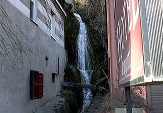
Although the stream is only 1.5 kilometres long, it has an interesting feature. At one point its waters drop through a height of 12 metres to form the Weissbach Waterfall (Weissbachfall), which is audible and visible from the nearby street. A small hotel has built a power plant there and uses the electricity generated for domestic requirements. Around the basin are canals, which divert the water in case of emergency.
Normally the water is of Grade B quality. Another feature is the high water speed near the mouth (~120 km/h).