
Hangul 땅끝 / 토말 Revised Romanization Ddangkkeut / Tomal | Hanja none / 土末 McCune–Reischauer Ttangkkeut / T'omal | |
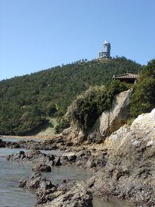 | ||
Walking tour 2016 09 ttangkkeut observatory
Ttangkkeut or Ddangkkeut, located at Songho-ri (송호리 松湖里), Songji-myeon (송지면 松旨面), Haenam County, South Jeolla Province, South Korea, is the southernmost area of the Korean peninsula. It is also called Tomal, all of which mean "the edge of the land" in Korean.
Contents
- Walking tour 2016 09 ttangkkeut observatory
- Map of 536 920 EB9585EB819DEBA788EC9D84
- Video landscape 2016 09 views from the ttangkkeut observatory
- Local attractions
- References
Map of 536-920 %EB%95%85%EB%81%9D%EB%A7%88%EC%9D%84
Ttangkkeut Village (Ttangkkeut maeul, 땅끝마을) lies in the area where Galdusan, a small mountain stands.
Wando Islands, also favorite tourist zone, are located less than an hour's drive from Ttangkkeut village.
Video landscape 2016 09 views from the ttangkkeut observatory
References
Ttangkkeut Wikipedia(Text) CC BY-SA