
 | ||
Fingerstyle finesse 2 song for tsenacommacah acoustic guitar lessons stephen bennett
Tsenacommacah (pronounced /ˌsɛnəˈkɒməkə/ in English; "densely inhabited land"; also written Tscenocomoco, Tsenacomoco, Tenakomakah, Attanoughkomouck, and Attan-Akamik) is the name given by the Powhatan people to their native homeland, the area encompassing all of Tidewater Virginia and parts of the Eastern Shore. More precisely, its boundaries spanned 100 miles (160 km) by 100 miles (160 km) from near the south side of the mouth of the James River all the way north to the south end of the Potomac River and from the Eastern Shore west to about the fall line of the rivers.
Contents
- Fingerstyle finesse 2 song for tsenacommacah acoustic guitar lessons stephen bennett
- Twin guitar bandoleros song for tsenacommacah
- History
- References
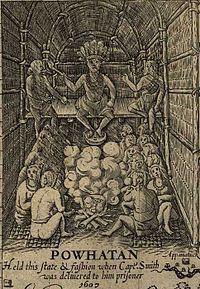
The Powhatan were part of a powerful Chiefdom of Virginia Indian tribes, also known as the Powhatan Confederacy, that spoke an Algonquian language. By the time the English arrived in Tsenacommacah, the Powhatan Indian Chiefdom included over 30 tribes. Each tribe had its own name and chief (werowance/weroance or weroansqua if female), and the chiefdom as a whole was ruled by a paramount chief (mamanatowick) named Wahunsenacawh, or more popularly Chief Powhatan.
The Eastern Shore Indians, the Accawmacke, who numbered around 2000, paid nominal tribute to the Powhatan, but enjoyed a large degree of semi-autonomy under their own paramount chief, Debedeavon ("the Laughing King").
Twin guitar bandoleros song for tsenacommacah
History
By early 1609, relations had begun to sour between the Powhatan and the English. As a result Powhatan moved his primary residence from Werowocomoco, off the York River, to Orapax (or Orapakes), located in a swamp at the head of the Chickahominy River. By 1614 Powhatan had again moved his primary residence, this time further northwest to a location on the north bank of the Pamunkey River known as Matchut. Matchut was not far from where Powhatan's brother Opechancanough ruled at Youghtanund.
Powhatan died in 1618, after which the chiefdom was ultimately passed to his younger brother Opechancanough, who led the Indian Massacre of 1622 as well as a second attack in 1644. Both attacks provoked English retaliations. A peace treaty, signed in 1646, brought an end to the conflicts between the Powhatan and the English. The treaty was signed by Opechancanough's successor Necotowance – Opechancanough himself was captured by the English and killed by an English guard in 1646.
As part of the treaty of 1646, the size of Tsenacommacah was reduced. The boundaries specified in the treaty separated Virginia Indian lands from those that were considered English-owned, and restricted crossings to those on official business. Badges were required for all visitors. The treaty also established the payment of a yearly tribute to the English, as well as delineating a number of tribal land reservations.
Among the surviving tribes of the now-dissolved Confederacy, the Appomattocs, Nansemonds and Weyanokes retreated to the south, becoming independent of Necotowance, as did the Powhites or Powhatan proper. The Pamunkey, Mattaponi, Chickahominy, Rappahannock, Kiskiack, Wiccocomico, Patawomeck, Morattico, Nanzatico, Sekakawon, and Onawmanient, occupying the peninsulas north of the York, were cut off from the southern tribes by the English enclave.
The Virginia Colony long respected its southern boundary established by this treaty, refusing to recognize settlements beyond it as late as 1705. However, the ban on settling north of the York river was lifted September 1, 1649, and a wave of new immigrants quickly flooded the northern tribes, leaving them scattered and isolated on ever-shrinking patches of land. That year, the Pamunkey weroance, Totopotomoi, received 5,000 acres (20 km2) for his tribe along both sides of the upper Pamunkey River, and the Kiskiack weroance, Ossakican was reserved 5,000 acres (20 km2) on the Piankatank. In 1650, another treaty reserved land for the creation of Indian towns, where 50 acres (200,000 m2) of land was granted per warrior. These lands became smaller and smaller in following years. Tracts were surveyed for the remaining tribes in the following decades, but these quickly shrank as they were either sold off or in some cases actually seized outright.
Following Bacon's Rebellion, The Treaty of Middle Plantation was signed by many Virginia Indian leaders in 1677, limiting Tsenocommacah even further. The treaty set up six reservations, reinforced the annual tribute payment to the English, and more fully acknowledged the Virginia tribes' subjection to the King of England.
All of the reservations, save two, were lost over the next two centuries. Even so, many of the remaining tribes still live in or near their ancestral lands. The Pamunkey and Mattaponi are the only tribes that still maintain their reservations from the 17th century. As such, these two tribes still make their yearly tribute payments, of fish and game, as stipulated by the 1646 and 1677 treaties. As far as anyone knows, the tribes have not missed a "payment" in 331 years. Every year, on the Wednesday before Thanksgiving, they go to the Virginia Governor's house in Richmond to make their yearly payment. A ceremony is held in which a deer, turkey, or fish and some pottery are presented to the governor. Before the ceremony a brunch is held where the tribes are able to converse with the governor. It has not always been easy for the Mattaponi and the Pamunkey to get the necessary items for their yearly payment, but they have made it a point of honor to uphold their end of the bargain.