
Topo map NTS 103J/2 Elevation 600 m | Age of rock Historical Easiest route drive Last eruption 1700 Mountain range Pacific Coast Ranges | |
 | ||
Similar Heart Peaks, Hoodoo Mountain, Cinnamon Butte, Crow Lagoon, Blue Lake Crater | ||
The Tseax Cone (/ˈsiːæks/ SEE-aks), also called the Tseax River Cone or the Aiyansh Volcano, is a young cinder cone and adjacent lava flows associated with the Nass Ranges and the Northern Cordilleran Volcanic Province. It is located east of Crater Creek at outlet of Melita Lake, southeast of Gitlakdamix and 60 kilometres (37 mi) north of Terrace, British Columbia, Canada.
Contents
- Map of Tseax Cone Kitimat Stikine A BC Canada
- Geology
- 17th century eruption
- Future and present
- References
Map of Tseax Cone, Kitimat-Stikine A, BC, Canada
The volcano is in a valley above and east of the Tseax River, about 20 kilometres (12 mi) south of the river's junction with the larger Nass River. The Tseax Cone is one of the most accessible volcanic centres in British Columbia.
Geology
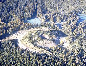
The Tseax Cone is in the southern part of the Northern Cordilleran Volcanic Province and is therefore part of the Ring of Fire. It has been the site of some of the youngest volcanic eruptions in Canada. It has been active at least twice in the past few hundred years and other remnants of lava flows exist in the area. It is 290 m (951 ft) in diameter at its base and rests on the remnants of an earlier and somewhat larger, dissected, 460 m (1,509 ft) diameter cone. The volcano is made of volcanic bombs and cinders with a crater at its summit where a churning lava lake poured and overflowed its rim during the 18th century.
Volcanism at the Tseax Cone is caused by the rifting of the Earth's crust where two parts of the North American Plate are breaking apart. The rifting is the result of the Pacific Plate sliding northward along the transform Queen Charlotte Fault, on its way to the Aleutian Trench.
The lava emitted in eruptions at the Tseax Cone is fluid. Its lavas are made of basalt, a common grey to black or dark brown extrusive volcanic rock low in silica content (the lava is mafic) that is usually fine-grained due to rapid cooling of lava on the Earth's surface. Pāhoehoe is found at the volcano, which has a smooth, billowy, undulating, or ropy surface. A pāhoehoe flow typically advances as a series of small lodes and toes that continually break out from a cooled crust. It also forms lava tubes where the minimal heat loss maintains low viscosity. However, there is also basaltic lava at the volcano characterized by a rough or rubbly surface composed of clinker called ʻaʻā. The clinkery surface covers a massive dense core, which is the most active part of the flow. As pasty lava in the core travels downslope, the clinkers are carried along at the surface.
17th century eruption
The Tseax Cone was the source for a major lava flow eruption between 1668 and 1714 that travelled into the Tseax River, damming it and forming Lava Lake. The flow subsequently travelled 11 km (7 mi) north to the Nass River, where it filled the flat valley floor for an additional 10 km (6 mi), making the entire lava flow approximately 22.5 km (14 mi) long.
The Nass River valley contains abundant tree casts and lava tubes. The tree casts were formed when the hot lava flow burned out tree trunks leaving holes in the lava. Lava tubes formed when the low-viscosity hot alkali basaltic lava travelled beneath the surface which eventually flowed out leaving the crust as the roof and walls of the tubes.
Legends of the Nisga'a people tell of a prolonged period of disruption by the volcano, including the destruction of two Nisga'a villages. Several Nisga'a people dug pits for shelter but approximately 2,000 Nisga'a people died due to volcanic gases and poisonous smoke (most likely asphyxiation by carbon dioxide). The Nisga'a story of the destruction is Canada's worst known geophysical disaster.
The lava beds, which reach 12 m (39 ft) above the road in some places, are the burial ground of these people. It is the only eruption in Canada for which legends of First Nations people have been verified. The lava flow can also be found near modern Nisga'a villages, such as Gitlakdamix. This eruption is just one of hundreds that have modified the landscape of western Canada over the past million years.
It has recently been suggested that the Tseax eruption was related to the Cascadia earthquake of 26 January 1700. This was the most powerful earthquake during the last 1000 years in the Pacific Northwest. If this theory is substantially correct, then another hazard must be added to those risks associated with major megathrust earthquakes.
Future and present
As of 2015, the volcano quietly rests in the 17,683-hectare Nisga'a Memorial Lava Beds Provincial Park. But the Tseax Cone could reawaken at any time. Before the 18th century eruption, the volcano erupted in 1325. Gases currently being emitted by the volcano are evidence that the volcano is still active and potentially dangerous. Signs of unrest such as seismic activity and increased gas output will almost certainly precede any future eruptive activity from the Tseax Cone, and its past activity is an extremely important factor for hazard assessment.
If the Tseax Cone erupts again, there may be a repeat of the poisonous gas disaster (as happened to the Nisga'a people). It could cause forest fires and could dam local rivers (as happened to the Tseax and Nass River) if the volume of the lava flows is large enough. If the lava flows again reach the Nass River, it could have disastrous short-term consequences for the important salmon fisheries on the Nass River system.
People living in the region still have limited knowledge of the dangers of the Tseax Cone if it becomes active or erupts. The relative lack of knowledge on the previous eruptions would need modern monitoring and include studies of the gases emitted by the volcano. Warning systems for people living downslope and downwind from the volcano would need to be created.