
Type saline Surface area 180 acres (73 ha) Surface elevation 0 cm Mean depth 40 cm Catchment area 3.213 km² | Average depth 1.3 ft (0.40 m) Area 73 ha Catchment area 3.213 km² | |
 | ||
Primary inflows Similar Ninigret National Wildlife R, Sachuest Point National, Trustom Pond National, Block Island National, John H Chafee National | ||
Trustom pond nwr rhode island
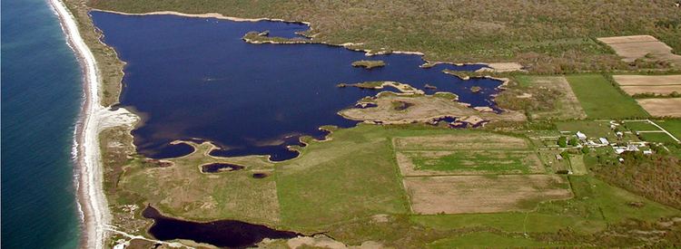
Trustom Pond is a closed lagoon in South Kingstown, Washington County, Rhode Island, United States. It is one of nine coastal lagoons (referred to as "salt ponds" by locals) in southern Rhode Island. It has a surface area of 800 acres (320 ha), and is the only undeveloped salt pond in the state. The pond averages 1.3 feet (0.40 m) deep, and has a salinity level of 5 parts per thousand. It is non-tidal, except when breached by storms. The water directly receives about 219,844,022 US gallons (832,200,150 L) of precipitation per year, with an estimated 796,215 US gallons (3,014,000 L) in daily groundwater flow. No streams flow into the pond, though a nearby stream "captures water that otherwise would have flowed to Trustom Pond".
Contents
- Trustom pond nwr rhode island
- Map of Trustom Pond South Kingstown RI 02879 USA
- Snapping turtle trustom pond
- References
Map of Trustom Pond, South Kingstown, RI 02879, USA
Trustom Pond National Wildlife Refuge is a National Wildlife Refuge, inhabited by over 300 species of birds, 40 species of mammals, and 20 species of reptiles and amphibians. As such, it is a popular bird-watching destination. In 1987, 365 acres (148 ha) of land were donated to the U.S. Fish and Wildlife Service; subsequent donations and purchases raised the protected area to 800 acres (320 ha), with current plans for expansion. The wildlife refuge receives approximately 50,000 visitors annually. The Trustom Pond National Wildlife Refuge includes 3 miles (4.8 km) of foot trails, surrounded by fields, shrublands, woodlands and small freshwater ponds. Wildlife managers create breachways to the Block Island Sound, lowering water levels and creating mudflats which become feeding areas for waders.