
Length 32 km | ||
 | ||
River mouth St. Johns Riverat Sandfly Point. Bridges Trout River Bridge, Hutchins Covered Bridge | ||
The Trout River is a 20-mile-long (32 km) tributary of the St. Johns River in Duval County, Florida. Located entirely within Jacksonville, the river is brackish in its lower section. The widest point of the river is near the St. Johns River, where it is 0.6 miles (1.0 km) across. The Trout River has wetlands as far as the mouth of the river's longest tributary, the Ribault River.
Contents
- Map of Trout River Jacksonville FL USA
- Tributaries
- Course
- Destinations along the river
- Riverside parks
- References
Map of Trout River, Jacksonville, FL, USA
Tributaries
Major tributaries of the Trout River include the Ribault River, Little Trout River, and Moncrief Creek.
Course
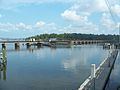
Beginning in northwestern Jacksonville, in Duval County, the river starts out as a creek. 0.03 miles (0.048 km) east of the source, the river is crossed by U.S. 1. 0.4 miles (0.64 km) downstream, the creek passes through the subdivision of River Falls. After this, the river widens into wetlands with a multitude of tributaries. 2.3 miles (3.7 km) downstream, a long tributary named the "Little Trout River". It originates at the forest at the corner of U.S. 1 and Interstate 295. 2.1 miles (3.4 km) downstream, Lem Turner Road (State Road 115) crosses the river as the C Ray Greene Bridge. 2.2 miles (3.5 km) downstream, the river becomes brackish. There is also the Ribault River, the longest of the three main tributaries. 0.7 miles (1.1 km) downstream, Interstate 95 crosses the river as the Trout River Bridge. 0.4 miles (0.64 km) downstream is Moncrief Creek, the third and last tributary of the Trout River. 0.7 miles (1.1 km) downstream, U.S. Route 17 crosses the river, spanning 0.2 miles (0.32 km). 1-mile (1.6 km) downstream is the St. Johns River, the mouth of the river at Sandfly Point.
Destinations along the river
Western Terminus: Old Kings Road
Eastern Terminus: Lem Turner Boulevard
Riverside parks
Coordinates: 30°23′23″N 81°39′22″W
Coordinates: 30°24′54″N 81°41′19″W