
River mouth Narayani River Tributaries Right:
Zarong-chu Sources Tibet, Gosaikunda | River system Narayani River Mouth Gandaki River Countries China, Nepal | |
 | ||
Main source Gosaikunda, Rasuwa, Nepal | ||
The Trishuli River (Nepali: त्रिशूली नदी; simplified Chinese: 特耳苏里河; traditional Chinese: 特耳蘇里河; pinyin: Tè'ěrsūlǐ Hé) is a trans-boundary river and is one of the major tributaries of the Narayani River basin in central Nepal. It originates in Tibet Autonomous Region of China where it is called Kirong Tsangpo (Tibetan: སྐྱིད་གྲོང་གཙང་པོ།, Wylie: skyid grong gtsang po, THL: Kyirong Tsangpo; Chinese: 古隆藏布; pinyin: Gǔlóng Zàngbù).
Contents
Map of Trishuli
EtymologyEdit
The Trishuli is named after the trishula or trident of Shiva, a powerful god in the Hindu pantheon, There is a legend that says high in the Himalayas at Gosaikunda, Shiva drove his trident into the ground to create three springs – the source of the river and hence its name Trisuli. In the Tibetan name, the suffix Tsangpo denotes a river flowing from or through Tsang, i.e. Tibet west of Lhasa.
CourseEdit
The westernmost parts of Tsang province are traditionally known as Lato, the highland region of Tibet. North Lato comprises the upper reaches of the Yarlung Tsangpo and Raga Tsangpo. South Lato comprises the upper reaches of Bum-chu, Matsang Tsangpo and Kyirong Tsangpo.
The Kyirong gorge and valley form one of Tibet’s most picturesque alpine regions. Dzongka, the capital of Kyriong County overlooks the confluence of the Kyirong Tsangpo and its main tributary, the Zarong-chu. The Kyirong gorge opens out at Ragma (3000 m).
Thereafter, it flows through Nepal and joins at Devghat the Narayani River, which at a lower stage flows into India and joins the Ganges.
Basin dataEdit
More than 60 per cent of the total drainage basin of the Trishuli lies in Tibet with about 9 per cent being covered by snow and glaciers. 85 per cent of its catchment area of 4,640 square kilometres (1,790 sq mi) lies above 3,000 metres (9,800 ft) out of which 11 per cent lies above 6,000 metres (20,000 ft). It has been regularly gauged at Betrawati at an elevation of 600 metres (2,000 ft). The average lowest and the melt season discharges of this river are close to average discharges recorded on the Narayani River....
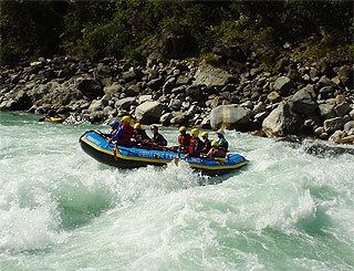
Water sportsEdit
Trisuli is Nepal’s most popular rafting river with impressive gorges, exciting rapids, some easier sections and easy accessibility from Kathmandu and Pokhara. Easy access to the Prithivi Highway makes “breaking off” the journey easy. Chitwan National Park is also easily accessible.