
Type man made Primary outflows Mud Creek Max. length 3,000 ft (910 m) Area 26 ha Mean depth 2.13 m Catchment area 259 ha | Primary inflows Surface elevation 1,098 m Length 914 m Width 427 m | |
 | ||
Similar Mount Hood, Timberline Lodge, Cascade Range, Mirror Lake, Mount Hood Skibowl | ||
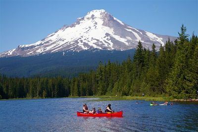
Trillium Lake is a lake situated 7.5 miles (12.1 km) south-southwest of Mount Hood in the U.S. state of Oregon. It is formed by a dam at the headwaters of Mud Creek, tributary to the Salmon River. It was created by the state Department of Fish and Wildlife in 1960.
Map of Trillium Lake, Oregon 97028, USA
The area which is now the lake was part of the Barlow Road, a component of the Oregon Trail. A log road across marshes allowed immigrants to pass to Summit Meadow, which was a toll station 1866—1870. Trillium is a genus of flowers particularly noticeable in the area.
The lake is popular for fishing, camping and photography, often clearly reflecting Mount Hood. Adjacent Trillium Lake Campground is administered by the Zigzag Ranger District of the Mount Hood National Forest. The large campground features a seasonal boat ramp and wheelchair-accessible floating dock. The lake is a very popular Nordic skiing destination from a trailhead across U.S. Route 26 from Snow Bunny. Some resources note its popularity on afternoons and weekends.