
Length 6.5 mi (10.5 km) Elevation change 3,200 ft (980 m) | Use Hiking Phone +1 865-436-1200 | |
 | ||
Trailheads Mount Le Conte, Tennessee (Trailhead off the Roaring Fork Motor Nature Trail, near Gatlinburg, TennesseeTerminus near the LeConte Lodge Highest point Terminus near the LeConte Lodge Address Great Smoky Mountains National Park, Roaring Fork Motor Nature Trail, Gatlinburg, TN 37738, USA Similar Great Smoky Mountains, Rainbow Falls Trail, Bullhead Trail, Alum Cave Trail, Mount Le Conte | ||
The Trillium Gap Trail is an American hiking trail in the Great Smoky Mountains National Park, in Sevier County, Tennessee. The trail ascends Mount Le Conte, the tallest (and sixth highest) mountain east of the Mississippi River and passes both Grotto Falls and Trillium Gap before reaching the LeConte Lodge, near the summit. The trail to Grotto Falls is one of the busiest in the national park.
Contents
- Trillium gap trail grotto falls to mt leconte
- Vital information
- Landmarksoverlooks
- Trailhead to Grotto Falls
- Grotto Falls to Trillium Gap
- Trillium Gap to the LeConte Lodge
- Maps and Directions
- Topographic Maps
- References
Trillium gap trail grotto falls to mt leconte
Vital information
Landmarks/overlooks
Trailhead to Grotto Falls
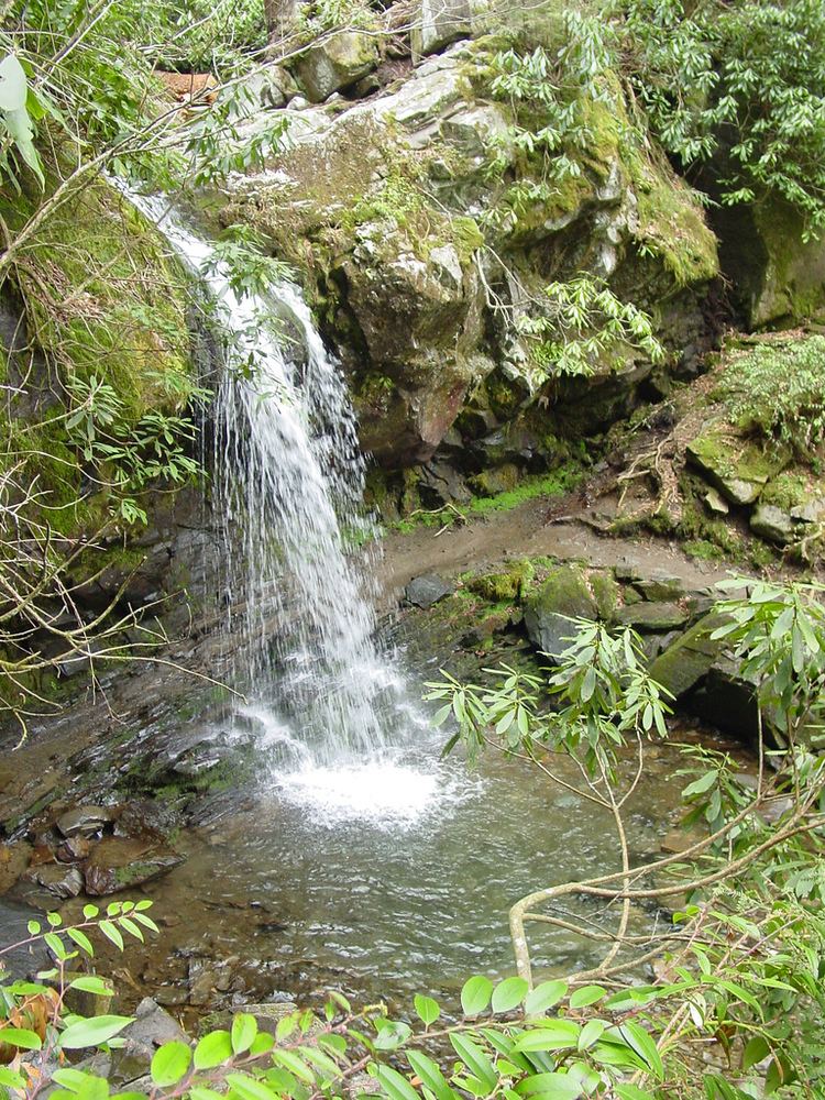
The Trillium Gap Trail begins its 6.5-mile (10.5 km) journey up the northern face of Mount Le Conte in an old-growth Eastern Hemlock grove, at an elevation close to 3,200 ft (975 m). Although very easy (only rising 500 feet (150 m) in elevation over the first 1.5 miles), this portion of the trail does contain many small creek crossings, so the hiker may want to brush up on his/her rock hopping skills prior to taking on the trail. After the third small stream, Roaring Fork sidles up along the path, signalling the soon-approaching Grotto Falls at 1.3 miles (2.1 km). Here Roaring Fork tumbles thirty feet (9 m) over the falls, which the trail actually passes behind on its way to Trillium Gap and points beyond. Grotto Falls is one of the most picturesque waterfalls in the park, and inasmuch can draw quite the crowd on certain days.
Grotto Falls to Trillium Gap
Once the hiker crosses the sometimes treacherous Roaring Fork (particularly after heavy rains), s/he begins a more steady ascent towards Le Conte. The trail here becomes more narrow and progressively rockier, a combination of the gain in elevation and loss of heavy activity along the trail. About a mile past the falls, the path enters into an expansive boulder field, where yet another small creek plummets down towards Roaring Fork. At 2.9 miles (4.7 km) the trail comes to Trillium Gap, tucked snugly between the peaks of Le Conte and nearby Brushy Mountain. Springtime hikers will be delighted by the brilliant carpetting of wildflowers underneath the American beech grove that dominates the area. The Brushy Mountain Trail extends to the left of the gap, which, if taken less than a half mile, offers excellent views of Le Conte and even the towns of Pigeon Forge and Sevierville from Brushy Mountain.
Trillium Gap to the LeConte Lodge
After leaving Trillium Gap, the trail continues climbing for 3.6 miles (5.8 km) towards its terminus. Along the way the hiker passes through a heath bald, similar to that found on Brushy Mountain, which is created in exposed, high elevation, areas where the soil is thin and heath family plants dominate. About a mile past the heath bald, the trail enters the fraser and spruce fir zone prevalent in the higher peaks of the Smokies. Fantastic views of the towns of Sevier County are available here when weather permits, sometimes even extending to the outskirts of Knoxville, as the hiker closes in on the LeConte Lodge. The LeConte Lodge provides the only commercial lodging in the national park, as it operates about 10 rustic cabins with no electricity or appliances. The Lodge also operates an office which provides t-shirts and other merchandise for hikers and various amenities for guests of the lodge. For many, this signals the end of their journey, but the actual peaks of Le Conte all have separate trails a short distance from the lodge, with Cliff Tops and Myrtle Point each offering expansive panoramas of the mountains and valleys below.
Maps and Directions
"Great Smoky Mountains National Park: Plan Your Visit: Grotto Falls".
"Great Smoky Mountains National Park: Maps".
Topographic Maps
The Trillium Gap Trail is shown on the following 1:24,000-scale topographic maps published by the National Park Service:
"Mt Le Conte Quadrangle, Great Smoky Mountains 7.5 minute 1:24,000-scale series Topographic Maps." (PDF).